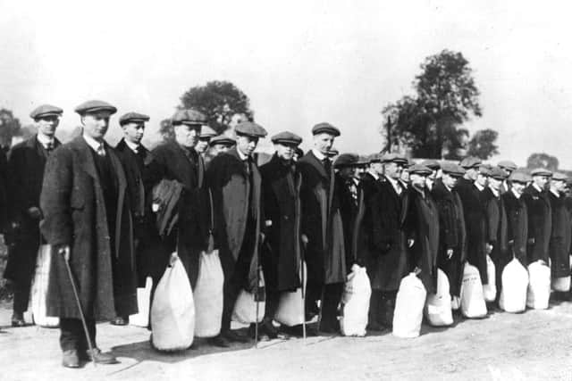
Weekend Walk: Colsterdale Camp


A remote area known as Breary Banks in Colsterdale, to the west of Masham, was where the 15th battalion of the West Yorkshire Regiment (the “Leeds Pals”) had their training camp and prepared for action in WWI. On 1st July 1916, in the first few minutes of the battle, 15 officers and 233 other ranks were killed, and on that day alone two whole Leeds Pals companies were wiped out. The scale of their losses adds huge poignancy to the walk, which is mostly on quiet country lanes. There is a memorial on the site of their camp, and you can still make out the hut foundations. A short distance to the west are some less visible training trenches.
1. Leave the car park next to the River Burn by walking eastwards along the single-track road with care. On the right, good views across Colsterdale open out towards what remains of the Leeds Pals camp at Breary Banks, below the plantation. The barracks foundations are near the memorial cairn.
Advertisement
Hide AdAdvertisement
Hide Ad2. Just past Pasture House on the right, stop to look south to a building called Pinewood Manor. In 1914 it was known as “The Bungalow” and became the officers’ mess for the Leeds Pals regiment. Further along the road, look sharp right for a clearer view of the surviving outline of Breary Banks camp. Continue onwards to a road junction.
3. Turn right on the Masham-Lofthouse road. This is the route the Leeds Pals marched along in September 1914 after travelling by train to Masham. They had received a huge send off from crowds at Leeds Station. Continue down to Leighton Bridge.
4. Cross the bridge and turn right. A brown signpost points the way to the Leeds Pals Memorial. Along the single track road pass Crab House farm, The Lodge, and an old Methodist Chapel. Eventually, on the left appears the memorial cairn to the Leeds Pals. It is possible to see the foundations of their billets on both sides of the road.
5. Continue past the memorial. The road swings left before the route takes a sharp right turn. Fields on either side were the site of training trenches. Look to the north west of farm buildings to see a break in the drystone wall, which was made for the Leeds Pals rifle range.
Advertisement
Hide AdAdvertisement
Hide Ad6. Pass Pikersgill House, following the Six Dales Trail northwards. Cross a footbridge and continue to a gate leading into woodland and follow the path to another gate. Leave the wood, go round the slope to cross a footbridge over the River Burn and return to Gollinglith Foot.
Difficulty Rating: 1 stars
Time: 1 1/2 hours
Distance: 3 1/2 miles
Maps: OS Landranger (1:50000) sheet 99 Northallerton & Ripon
Parking: Gollinglith Foot SE 153809
Public transport: No convenient bus service available for this walk.
Refreshments and toilets: Masham, Lofthouse.