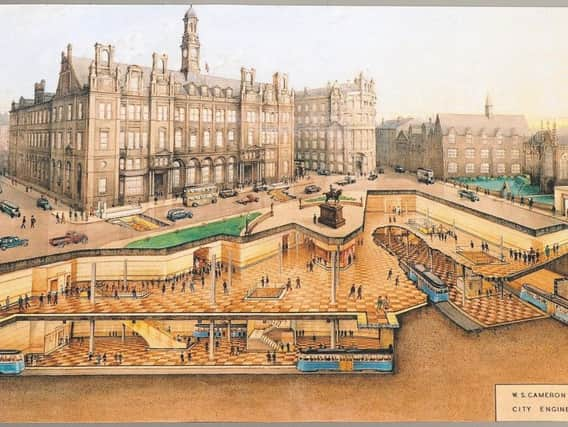
This is the extensive Leeds underground system that was never built


The National Tramway Museum released an artists' impression from their archives of how the network would have looked last year - and it offers a fascinating glimpse into what could have been for a city now plagued by transport issues.
How can we improve transport in Leeds?The initial plans were first drawn up in the late 1930s - but World War Two and post-war austerity stopped the subway lines from ever being built.
Advertisement
Hide AdAdvertisement
Hide AdConstruction to begin on new Elland Road transport schemeThere would have been stations beneath key locations such as City Square, Briggate and the Corn Exchange and the network was intended to replace the city's trams, which were eventually scrapped in the 1950s.
The map would have included three lines - one from Woodhouse Lane to Wellington Street, another from North Street to Marsh Lane and a circular route to the south of the city centre.
In 1944, the plans were amended and expanded, but the total cost of the scheme would have been in excess of £2million - a huge amount back in the 1940s, and one which would have required a large loan to pay off at a time when the country's economy was struggling in the aftermath of war.
The proposals were abandoned in 1945, when Labour took control of Leeds City Council.
Advertisement
Hide AdAdvertisement
Hide AdAlthough many lament the loss of the scheme, it's noticeable that very few of the city's suburbs would have been within walking distance of a station, and the lines would mainly have been used as quick way to travel around the city centre.
Line one - east to west
This route would have travelled from Woodhouse Lane, close to the Blackman Lane junction, via The Headrow, Briggate, Boar Lane, City Square and Wellington Street. It would have served the University of Leeds.
Line two - North Street to Marsh Lane
This line would have started from the current site of the Leeds College of Building, converging with the first line underneath Briggate, and then travelling eastwards to Marsh Lane via Corn Exchange, Call Lane and New York Street.
Line three - south circular
The only one of the lines which would have had to pass underneath the River Aire. It would have formed a loop around the city centre from Commercial Street in the north to its southern boundary at Great Wilson Street - close to where Asda House and the Holbeck Urban Village are today. The stations would have been at Meadow Lane, the Corn Exchange, Briggate and City Square.