The Iron Age hill fort in Yorkshire that was discovered by accident


Roulston Scar in the North York Moors was once one of Britain's largest Iron Age fortifications - but it wasn't properly surveyed until 2000.
Although archaeologists had been aware for decades that there were traces of prehistoric remains in the Sutton Bank area, near Thirsk, they were shocked to discover just how extensive the 60-acre site on a plateau was.
Advertisement
Hide AdAdvertisement
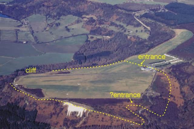
Hide AdGormire Lake: The Yorkshire lake shrouded in myths and mysteryEnglish Heritage investigators spent a summer working at the site at the start of the 21st century, and were amazed to find evidence of a stronghold built from timber and surrounded by limestone ramparts. It dated from 400BC.
As well as a defence against raids by hostile tribes, the fort is thought to have played a wider social role as a seat of political power, and large assemblies may have been held there.
At the time of the find, English Heritage archaeologist Alastair Oswald admitted that there were several puzzles surrounding the huge scale of Roulston Scar. It would have taken a 'vast' amount of labour to build, and 3,000 trees would have been needed to supply wood. It was completed over a period of several years during a time when the area was sparsely populated and it was difficult to organise collaborative building projects.
Iron Age chariot and horses found in grave in PocklingtonEven more intriguingly, unlike other hill forts of its size, Roulston doesn't seem to have been a permanently inhabited settlement, suggesting it was manned by just a force of guards without families or non-combatants alongside them.
Advertisement
Hide AdAdvertisement
Hide AdIt was 'lost' for centuries for various reasons, despite clues to its existence being found. The famous chalk carving of the White Horse of Kilburn obliterated part of the ramparts, and an error on a Victorian map also misled historians. Ordnance Survey mapped a stretch of earthworks in the mid-19th century, but they were mistakenly linked to the Casten Dyke boundary nearby, which is of much later origin.
The theory is that Roulston, the largest fort in the north of England, was constructed as a result of tribal conflict in the area.
Summer 2018 heatwave reveals Iron Age burial mounds in Yorkshire WoldsEnglish Heritage teams found ancient ditches and banks during their 2000 survey, and discovered that the artificial steepening of the natural scarp extended around the full circuit of the plateau, much further than had been previously thought.
There had been some previous digs, in 1969 and 1970, which had unearthed evidence of a trench and box rampart fronted by a four-metre-high timber palisade topped by a defensive walkway.
Advertisement
Hide AdAdvertisement
Hide AdRoulston Scar is currently the home of a gliding club, as it makes an excellent launch site. During World War Two, there were fears that it would be used as a landing strip if a Nazi invasion was successful, as many German gliding enthusiasts had visited the club before the war and were familiar with the landscape.