Scorched land gives up its secrets


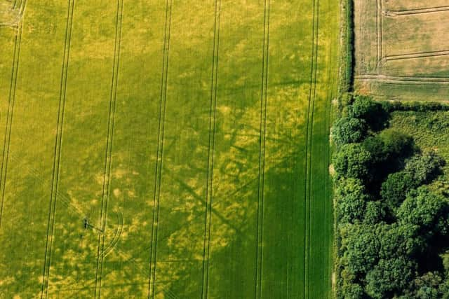
Archeologists, surveying the patchwork of arid fields from above, have discovered new traces of England’s buried history, including neolithic ceremonial monuments, Iron Age settlements and a Roman farm. The evidence has been seen for the first time in cropmarks – patterns left in crops and grass.
Among the most remarkable discovery is of Iron Age square barrows at Pocklington in the Yorkshire Wolds, where marks of four squares indicate the distinctive remains of a burial site, experts at Historic England said.
Advertisement
Hide AdAdvertisement
Hide AdAlthough rare nationally, such barrows are common in the Wolds and are sometimes associated with elaborate burial rituals.
Last year, Pocklington was the site of the discovery of a chariot and horse buried together – a find described as one of the most significant of the last half century.
The new discoveries also include two Neolithic “cursus” monuments near Clifton Reynes, Milton Keynes, and a Roman farm at Bicton in Devon, where cropmarks in a field of grass cut for silage have been revealed.
Duncan Wilson, chief executive of Historic England, said the dry weather had enabled scientists to “see beneath the soil”.
Advertisement
Hide AdAdvertisement
Hide AdHe said: “Cropmarks are much better defined when the soil has less moisture.
“The exceptional weather has opened up whole areas at once rather than just one or two fields, and it has been fascinating to see so many traces of our past graphically revealed.”
More details of the lost Elizabethan buildings and gardens associated with Tixall Hall in Staffordshire can also be seen through the drought, revealing the buried foundations of the original 1555 building and a new hall started during the First World War, but demolished in 1926.
And at Eynsham in Oxfordshire, a circle of pits not visible for years, reveal the buried remains of funeral monuments that could date back to 4000BC.
Advertisement
Hide AdAdvertisement
Hide AdHistoric England uses aerial photography of cropmarks to produce archaeological maps which help to assess the significance of buried remains and can be used to make decisions about protecting them from development or damage caused by ploughing.
Helen Winton, the organisation’s aerial investigation and mapping manager, said it was “very exciting” to have had the hot weather for so long.
The last “exceptional year” was 2011, when more than 1,500 sites were discovered, she said.
The experts said that even in an area as well explored as the Yorkshire Wolds, extreme weather could still throw up new discoveries.
Advertisement
Hide AdAdvertisement
Hide AdDamian Grady, the agency’s aerial reconnaissance manager, said: “This has been one of my busiest summers in 20 years of flying and it is has been very rewarding making discoveries in areas that do not normally reveal cropmarks.”