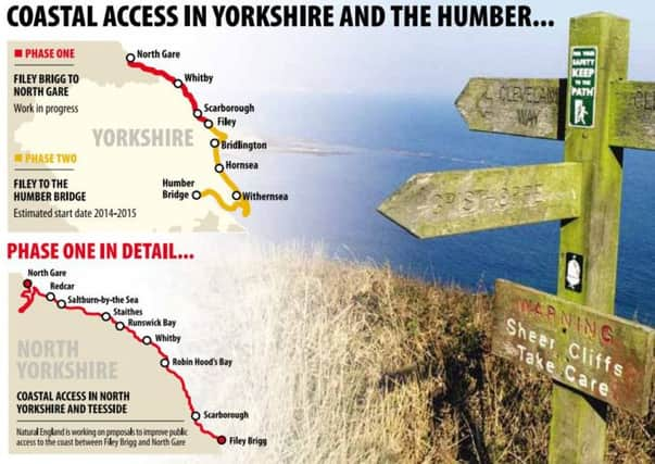
Walkers’ dream of coastal path comes a step closer to reality


The England Coastal Path, a 3,000-mile route round the whole of England, connecting the fishing villages of North Yorkshire with the wide-open landscapes of Holderness and beyond, has long been an aspiration of walkers.
But earlier this year there were fears the project would succumb to Government funding cuts when a Minister described it as a “sledgehammer to miss a nut”.
Advertisement
Hide AdAdvertisement
Hide AdLocal members of the Ramblers are delighted the path will go ahead, and believe it will boost tourism in less-known parts of the coastline, including remote Holderness.
Landowners in the first phase on Yorkshire’s coast – extending from Filey Brigg to North Gare, in Teesside, taking in Whitby, Staithes and Robin Hood’s Bay – are already being contacted.
Natural England expects the 124km stretch to be ready sometime during 2015/16.
The second phase will wend its way down the East Yorkshire coast, along Holderness and out to Spurn Point, coming back inland to Hull, and stopping at the Humber Bridge.
Advertisement
Hide AdAdvertisement
Hide AdCampaigns officer for the Ramblers, Anastasia French said: “Three months ago we didn’t know whether it was going to happen at all and we thought it was very likely to fall victim to spending cuts.
“From the map Natural England has produced it is going to go ahead quicker than previously thought and come next year they will actually start looking at where the routes will go and they will be talking to landowners about the ideal route, and hopefully presenting it to the Secretary of State in 18 months.
“It is currently going to open to the public in 2016/2017, but there is no guarantee on that.”
Currently just under a third of the East Yorkshire coast either has no access at all, or walkers have to rely on the goodwill of landowners.
Advertisement
Hide AdAdvertisement
Hide AdThe path will deviate inland around military sites and where gardens stretch right to the coast.
The legislation will allow for it to re-routed when it becomes dangerous because of coastal erosion.
East Riding Council was asked several years ago to be one of the pilot areas, but decided against.
Peter Ayling, president of the East Yorkshire and Derwent branch of the Ramblers, said he felt sure the authority would support it this time.
Advertisement
Hide AdAdvertisement
Hide AdHe was part of a team that recently surveyed the stretch between Aldbrough and Withernsea, part of the fastest eroding coast in Europe.
“It is fairly remote, very quiet and on a windy day it is exhiliarating,” he said. “It has all sorts of interesting features including World War Two emplacements, some of which have fallen over the edge.
“I hope it will run as close as it can to the cliffs because that’s what it is – a coastal path.”
Natural England hope to start work next year on proposals for a stretch of coast path in East Yorkshire, linking to the Cleveland Way National Trail at Filey.
Advertisement
Hide AdAdvertisement
Hide AdA spokeswoman said: “We intend to make a formal approach about this to East Riding Council shortly. We very much hope they will agree to work in partnership with us on this next stage towards the realisation of the England Coast Path.”
East Riding Council said they recognised the benefits the path could bring, but also the concerns about coastal erosion.
They would ensure there was detailed consultation led by Natural England “to ensure a balance is struck between the rights of landowners, the consequences of coastal erosion and the desire to establish the new path.”