Storm Freya ‘danger to life’ winds set to batter Yorkshire as weather warning issued


Forecasters predict the storm will hit this afternoon and may be severe enough to cause injuries and danger to life from flying debris.
Gusts of more than 50mph are likely heading into the evening. The yellow weather warning is in place from 3pm today to 6am on Monday morning.
Advertisement
Hide AdAdvertisement
Hide AdThe Met Office is warning that there could be some damage to buildings and trees, such as tiles blown from roofs and fallen branches and that some roads and bridges may close.
Road, rail, air and ferry services may be affected, with longer journey times and cancellations possible
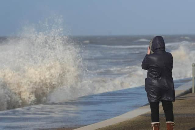
They also warn that power cuts may occur, with the potential to affect other services, such as mobile phone coverage and that injuries and danger to life could occur from large waves and beach material being thrown onto sea fronts, coastal roads and properties.
According to the Met Office, Yorkshire on Sunday will see a bright, dry morning but thickening cloud towards midday with rain moving north in the afternoon.
Advertisement
Hide AdAdvertisement
Hide AdThere Lighter winds at first before strengthening again as the weather warning hits.. The maximum temperature is 11 degrees celsius.
Met Office deputy chief meteorologist Jason Kelly said: “This is a developing situation and the track of Freya’s strongest winds could change over the next few days, so we are advising people to keep an eye on the latest forecast and warnings from the Met Office.
“Where winds are strongest we can expect significant disruption to travel, with damage to buildings and trees likely. It’ll be especially dangerous near coastal areas due to the wind whipping up large waves.”
Highways England’s Head of Road Safety, Richard Leonard, said: “We’re encouraging drivers to check the latest weather and travel conditions before setting off on journeys and consider if their journey is necessary and can be delayed until conditions improve.
Advertisement
Hide AdAdvertisement
Hide Ad“If you do intend to travel, then plan your journey and take extra care, allowing more time for your journey.“In high winds, there’s a particular risk to lorries, caravans and motorbikes so we’d advise drivers of these vehicles to slow down.“Drivers of other vehicles should be aware of sudden gusts of wind which can affect handling and braking, and give high-sided vehicles, caravans, and motorbikes plenty of space. In the event of persistent high winds we may need to close bridges to traffic for a period, so please be alert for warnings of closures and follow signed diversion routes.”