Yorkshire braced for another icy blast as rare North Pole weather phenomenon could send temperatures plummeting


Meteorologists have warned that freezing air within the Polar Vortex is being pushed south from the Arctic towards Britain in an event known as Sudden Stratospheric Warming (SSW).
Advertisement
Hide AdAdvertisement
Hide AdOnce here, it could result in another two weeks of bitter temperatures and prolonged icy conditions, potentially lasting right through until March.
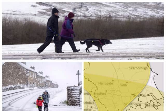
The Met Office has already issued a weather warning for Yorkshire to be aware of snow and ice on Friday with the threat of heavy snow, sleet or hail storms expected across Yorkshire.
A Sudden Stratospheric Warming last occurred four years ago but experts have warned the North Pole’s high-altitude air has suddenly warmed up and is set to expand the vortex further south.
News of the warming is contained in the UK government February to April forecast which has been briefed to the Cabinet Office, transport bosses, councils and emergency services.
Advertisement
Hide AdAdvertisement
Hide AdThe February to April contingency outlook said: “The probability of Sudden Stratospheric Warming is higher-than-normal in February. These events disrupt the stratospheric polar vortex and, more often than not, bring cold weather to the UK.”
Forecaster Dr Dave Reynolds, of The Weather Channel, said the mass of Polar air was set to expand and possibly drag bitter air towards the UK.
He explained: “There is a clear indication of an imminent split in the polar vortex, currently located over central-western Greenland.
Advertisement
Hide AdAdvertisement
Hide Ad“The main centre will drift to the Canadian Plains, while a new area will form over northern Russia.
“This will drift towards the Caspian Sea, then westwards across the Mediterranean, Iberia and out to the near Atlantic during the next two weeks, weakening as it does so.
“The process of vortex splitting is accompanied by sudden stratospheric warming, whereby temperatures in the stratosphere rise.
“This warming can then extend downwards through the depth of the atmosphere and result in an increased risk of blocking, which in winter-time raises the chance of widespread cold conditions developing.”
Advertisement
Hide AdAdvertisement
Hide AdThe last SSW event occurred four years ago, according to official data, and brought the coldest March for 51 years to Scotland, with snow and -12.5C lows as late as March 31 in Braemar, Aberdeenshire.
SSW events also triggered -16.1C lows in Altnaharra, the Scottish Highlands, during November 2010 - starting the month-long Big Freeze in December 2010.
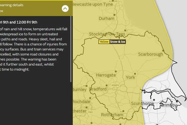
The Met Office warning for Friday states has been issued from midnight tonight through to midday tomorrow and states: “Following a spell of rain and hill snow, temperatures will fall quickly allowing widespread ice to form on untreated pavements, cycle paths and roads.
Advertisement
Hide AdAdvertisement
Hide Ad“Heavy sleet, hail and snow showers will follow. There is a chance of injuries from slips and falls on icy surfaces. Bus and train services may be delayed or cancelled, with some road closures and longer journey times possible.
The chief forecaster’s assessment reads: “Ice is expected to form as skies clear. Heavy sleet, hail and snow showers will follow, and these will be most frequent across Northern Ireland, western Scotland, northwest England and by morning across Wales and the north and west Midlands.
“Between two and five centimetres of snow may accumulate above 100m with some snow to low levels too.”
Yorkshire weather forecast for Thursday night:
Rain may become heavier for a time this evening. Turning colder and clearer later but with the risk of a spell of sleet or snow. Minimum Temperature 0 °C.
Yorkshire weather forecast for Friday:
Advertisement
Hide AdAdvertisement
Hide AdA colder day than Thursday with a strong northwesterly wind. Any sleet or snow clearing, leaving a largely bright day with the odd wintry shower. Maximum Temperature 5 °C.
Outlook for Saturday to Monday:
A wet and windy spell on Saturday will be followed by colder but brighter conditions on Sunday and Monday, with the odd wintry shower and overnight frosts.