Castle Howard uses New York footfall planning techniques for its farms, fields and woodlands

Castle Howard near York has developed a 15 year masterplan to overhaul its approach to its natural environment in a bid to make it more climate friendly, sustainable and profitable.
It includes major steps to protect and regenerate the 9,000 acre site for future generations and follows the appointment of a Chief Executive for the first time and also a head of natural environment to manage the business’ approach to nature and conservation whilst also having to operate as one of the region’s most popular tourist attractions.
Advertisement
Hide AdAdvertisement
Hide AdThere is a conflict between the two interests which is a matter for future planning but as a starting point, Castle Howard has embarked on a unique mapping exercise which uses satellite data to create a detailed digital map of its 9,000-acre estate, 2500 of which sit within the Howardian Hills AONB.
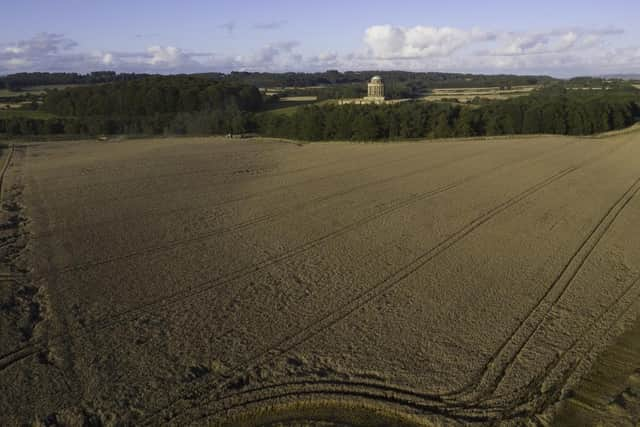

Covering everything from soil health to land permeability for wildlife, the map, known as the Natural Capital Baseline, will allow Castle Howard to scenario plan and visualise land management decisions as it looks at activities such as future carbon sequestration, the impact of regenerative farming and reforestation programs.
The high-resolution satellite images of the entire estate show what is going on from the sky with habitats, grassland, crops, woodlands, and farmland. It details what and where the 30 different habitat classes are within 30cms such as coniferous woodland, dry ditch, bare ground, marsh, bracken or open water.
It allowed the team to plan how things might work if an area was turned into ponds, if something was re-wilded or if another tourism attraction was brought.
Advertisement
Hide AdAdvertisement
Hide AdAnd if it isn’t right, they can delete it and start again without having disturbed the present environment.
Castle Howard has worked with Fera Science, based at Sand Hutton, near York, using its Land360 science and data led technology to create the map.
A similar method has been used in retail sectors for years but it has not been applied to land management.
Jasper Hasell, chief executive of the Castle Howard estate said: “You might see in Manhattan, footfall of retail sites at different times of day and decide to position a new shop there by looking at footfall. This is used a lot in retail or visitor attraction modelling and we are now using the technology for this purpose. We are using it in a way that has not been done before.”
Advertisement
Hide AdAdvertisement
Hide AdThe mapping has also been done of farms on the estate that have been leased to tenant farmers and the technology is being made available to them so they can plan better on their own farms and businesses.
He added: “We have done this on the whole estate that includes land farmed by tenant farmers but we will be able to make that available to them for their own process and decision making. I doubt many would go into that level on their own because it costs money and they are focused on farming.
“That goes back to the landlord and estate relationship with the tenant. It is an old model of everyone contributing and helping each other out. If you did not have estates with these relationships it would be every man for himself like many countries are and that is quite unique about this country as well.”
As the relationship between Castle Howard and Fera develops, it is hoped that the Land360 technology and approach can be used on other estates and North Yorkshire’s land areas across the region.
Advertisement
Hide AdAdvertisement
Hide AdMr Hasell said: “The exciting thing is - if we can make this model work at this level for this estate, why can’t it work for other estates and other regions, like North Yorkshire. Could we be a microcosm for a bigger way of solving some of today’s environmental and social problems? That is what I find exciting about it. We are able potentially to have solutions quicker than the government will be able to.”