Archaeologist's drone discovers outline of lost medieval moated manor house in fields of Yorkshire village

Tony Hunt, an electronic engineer and part-time researcher at the University of Hull, made the astonishing discovery in Hutton Conyers, near Ripon – and believes it is the foundations of the forgotten Old Hutton Hall.
The manor was owned by the Conyers family from the 12th century, and they would have drawn an income from farms which would have eventually enabled them to build a fortified manor house. These manors – ‘mini-castles’ with moats and other defences – represent a period between the building of motte and bailey castles and country houses during a time when conflict and instability were still major concerns for landowning families.
Advertisement
Hide AdAdvertisement
Hide AdAs wars became less frequent, lords of a manor would eventually replace the moated houses with new stately homes, often abandoning them to the elements. Villagers would be allowed to dismantle them to use the materials for building or repairing.

In Hutton Conyers’ case, there is a listed 16th-century farmhouse called Hutton Hall in the village, built by the Mallorys of Studley Royal, who acquired the manor when the Conyers estates were broken up.
The Conyers family ended up in nearby Norton Conyers, which was also in their ownership. By the late 14th century, the estates passed to the Norton family, who built Norton Conyers House. After the execution of Richard Norton, in 1624 it was acquired by the Graham family, who made additions to the house and remain living there today.
The site of the motte and bailey castle was used for motorbike scrambling in the 1960s and 70s.
Advertisement
Hide AdAdvertisement
Hide AdMr Hunt said: “Hutton was known as ‘Hotone’ at Domesday, with the suffix added after the Conyers family came into possession in the 12th century. Various families owned the village until it became a parish in the 19th century.
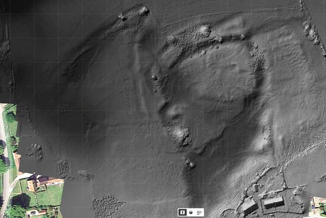
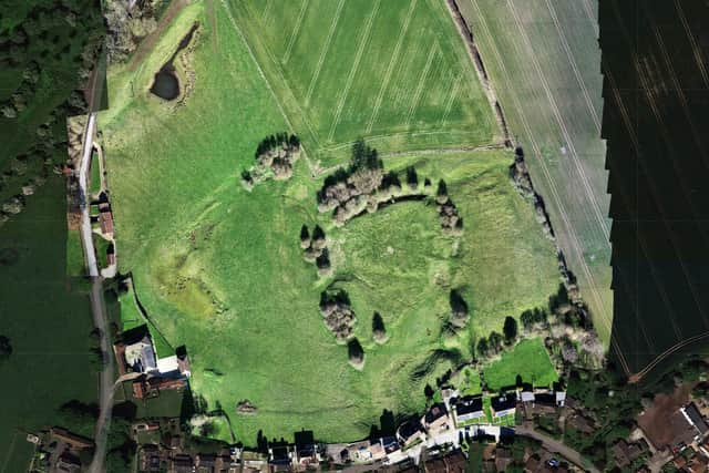
“Just north of the village centre there is a field. In this field lie various lumps and bumps. And so there should be, for this field is the site of Old Hutton Hall, apparently a lost moated manor house.
“The Historic England entry for this site is blank. The field offers no clue that here was the birthplace of Hutton Conyers village, and little is known about the site, its structure or its history.
“The Yorkshire Archaeological Aerial Mapping survey shows substantial water management, with the moat not of the traditional manor square shape, and more suggestive of a motte and bailey castle: the building platform could also easily be said to be a low motte.
Advertisement
Hide AdAdvertisement
Hide Ad“Careful examination of the last image appears to show the suggestion of footings of buildings on the flat area, with a causeway or bridge across to the east where what appears to be the remains of a bailey. Only detailed examination will tell the truth of this neglected site.

“And so perhaps this site is older than it seems, and in fact is not originally a moated manor but a Norman period otte and bailey, reused in later centuries for a manor house.
“Local legend states that the manor stood in the 1640s during the Civil War and was attacked by the Parliamentary forces in that conflict, but there appears to be little else known, and little effort made to learn.
“And so, like many other unregarded monuments lost in fields on the edges of our villages Hutton Conyers Old Hall has sunk back into the landscape that bore it, taking the takes of its construction, its life and its slow decline with it.”
Mr Hunt shares images from his investigations at various sites across Yorkshire on his Facebook page, Yorkshire Archaeological Aerial Mapping.