Four walks to blow the cobwebs away


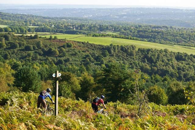
North: Brimham Rocks
Route: Moderate, 4 hours 45 minutes 15.0km/9.3m.
Start location: Nidd Bridge, Pateley Bridge.
1. Immediately before you cross Nidd Bridge from the town side, turn left along a public footpath. Follow this attractive riverside track for 2km/1.2miles, past a weir and large mill reservoir until you reach a road. Turn left here towards Glasshouses, but after a few metres go through a doorway in a wall on your right. Bear left, then right to pass in front of the mill. At its far side, just beyond the smoke house, and before a large building, turn right down a track that soon bends left back to the river.
2. The riverside path is clear, running up a bank to a stone stile at one point, then across a wooden one cutting across the corner of a field before rejoining the riverside and, further on, under a disused railway bridge. Ignore the footbridge across the river, and instead continue ahead until you reach a wide beck. Here, the path leads away from the river to cross the beck via a footbridge. Once on the far side, turn left and cross the field to reach the main road at Low Laithe.
Advertisement
Hide AdAdvertisement
Hide Ad3. Cross to the public bridleway opposite. When the tarmac surface ends, keep straight ahead along the track and follow it to the next road. Turn left here over the bridge, but a short way up the hill fork right onto a footpath signposted “Pateley Bridge”. You pass a pretty mill pond on the right, after which the beck flows below you through a deep ravine.
The course of the path is obvious from here on, passing through beautiful woodland as far as a footbridge, after which you bear right up a stony track; 30m before the derelict brick building, turn sharp left along a path through a birch wood, then fork right soon after, at the waymarker, along a narrower path.
Follow this as far as another fork where you should turn right through a gate and onto a grass path running in front of a farmhouse. At the end of the grass path go through a gate and turn right onto a track. Follow this uphill for 1.6km/1mile, past a farm, until you reach a junction with the National Trust Brimham Rocks access track.
4. Turn left up the track. Walk through the car park, and take the footpath to the left and on for 5–10mins through some amazing rock formations until you reach the National Trust Information Centre.
Advertisement
Hide AdAdvertisement
Hide AdAt the point where the tarmac track bends sharply right, just in front of the centre, head along the unsurfaced track branching left, which soon after narrows to a footpath. Follow this as it skirts more superb rocks, until you arrive at a big spread of open heather and a junction.
Instead of following the main path sharply to the right at this intersection, keep straight ahead for a short way, then bear left down a shallow valley as far as a surfaced track where the National Trust boundary is marked.
5. Turn left onto the tarmac and follow the track until you reach a right hand bend where the track becomes a driveway. At this point the footpath goes through a metal gate then runs along the left edge of a field, then bends right towards the houses. Follow the driveway ahead but where it swings sharply right, bear left along a clear footpath cutting across the field to a ladder stile.
Cross this and follow the wall along the end of the field, bearing left at the bottom to a second stile. Keep to the right of the next two fields on a well worn farm track with woods to your right, at the bottom of which a ladder stile leads to a footbridge over a beck. Cross and bear right up the track.
Advertisement
Hide AdAdvertisement
Hide AdAt the junction, take the track half left, which shortly after crosses a cattle grid. You’re now on the Nidderdale Way. When the wall on your right bends right, fork half right across the field to a gap in the wall ahead. Go through this and bear right to a stile, then keep left along the wall to reach some houses. Pass to their left, along a walled path, and turn left at the crosspath at the top. This track takes you to White Houses
6. At the junction, go straight over and follow the righthand fork, finger posted to “The Raikes”, which in a few metres leads to a gate. Go through this and continue for approximately 500m/550yrds to a farm access track, which takes you to a road. Turn right (uphill);then left at the Nidderdale Way sign and cross the stream; soon after you’re between two drystone walls.
7. At the next road junction, keep straight ahead and follow the lane for 230m/250yds. Just beyond the entrance to Rock House, fork right by a bench onto a public bridleway, signposted to “Pateley Bridge”, which runs past the houses of Blazefield to the B6265, which you turn left onto Walk down the hill to where the road bends left, head right along a track that is finger posted Knott & Panorama Walk.
This soon narrows between walls. Keep left at the next fork, continuing right on a tarmac lane through Knott. You’re now on the Panorama Walk, which takes you back to Pateley Bridge, with more stunning views over the valley. On reaching the hairpin bend, keep straight ahead past the entrance to the cemetery, then follow the path all the way down to the main road, turning right to regain the town centre and main street.
South: Fox House, Totley Moor, Blacka Moor circular
Route: Moderate, 4 hours 12.4km / 7.7m.
Start location: Fox House Inn, Hathersage Road, Sheffield.
Advertisement
Hide AdAdvertisement
Hide Ad1. From the car park cross Hathersage Road by the bus stop and turn right. Go down to the road junction, cross and turn right to a gate and fingerpost. Go through the gate and down to the access road to Longshaw Lodge Visitor Centre turning left along it. Just before the visitor centre turn left and follow a wide track as it bears right behind The Lodge through trees to exit through a gate.
Turn right along a wide grassy track and where it forks bear left on the track past the wooden pole (above to the left). This is believed to be the successor to an 18th century pack horse trail waymarker. Continue up to a triangular road junction and cross straight ahead over two roads (to Froggatt and Calver). Go through a gate ahead and continue on the track to the isolated White Edge Lodge.
2. Just before the Lodge take a path on the left by a wall and keep left uphill to a gate on the top of White Edge. Go through, turn left then immediately right continuing straight ahead over the moor. Look out for the stump of Lady’s Cross on your right.
On reaching a road turn right along it. Soon you will see a gate on the opposite side of the road. Cross, go through it and follow the narrow path ahead through the heather across the moor. Take care as a section of this path can be boggy. As you cross the moor you will see the ventilation shafts of Totley Tunnel. Eventually you reach the remains of a wall. Turn right and follow it ahead, passing a trig point to your left, across a track until you reach a large cairn.
Advertisement
Hide AdAdvertisement
Hide Ad3. Continue ahead downhill following the steep and rocky path which eventually bears left. At a wall turn left along a track as it winds below Brown Edge eventually joining Moss Road. Turn right on to this track, which soon becomes tarmaced, and follow it downhill, passing another ventilation shaft, until it meets Lane Head Road. Turn left along it at the back of the sports ground to a road junction.
4. Turn left into Strawberry Lee Lane and follow it round until it reaches a small car parking area on the left. Go through a gate ahead and continue along the path into (D) Blacka Moor Nature Reserve, a Site of Special Scientific Interest. Follow the path as it starts to climb steeply with a brook down to the left. At a junction keep left and continue up the side of Blacka Hill until you reach and go through a gate in a wall.
5. At the way markers follow the signs to Longshaw going straight ahead onto a narrow, grassy path uphill bearing to the left side of the hill in front of you. Eventually go over a stile and through a gate , turning right onto a grassy track. Follow this to a road (A625), cross and continue, through a gate, on the path as it winds over the moor to join Hathersage Road (A6187). Turn left for a short distance downhill then cross to enter the car park and the start of the walk.
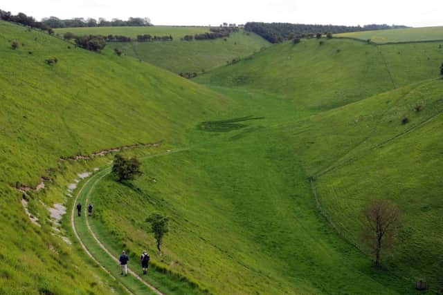
East: Fridaythorpe Circular
Moderate: Five hours, 16.4km/ 10.2m.
Start location: Park by village green, Fridaythorpe.
1. Head to the main road, turn right and soon turn left along Huggate Lane (the route is clearly signed Yorkshire Wolds Way). The lane becomes a track and reaches a junction.
Advertisement
Hide AdAdvertisement
Hide AdFridaythorpe is notable for being the highest village on the Yorkshire Wolds, and is also the halfway point of the 79 mile Yorkshire Wolds Way National Trail, which begins on the banks of the Humber and finishes at the headland of Filey Brigg in the north.
The 12th century Norman church is the oldest building in the village. Of particular note is the black and white clockface on the tower, with the words ‘Time is short, eternity is long’ at the bottom. Of note, too, is the attractivebus/walkers’ shelter alongside the village green, one of a number of public artworks along the Yorkshire Wolds Way.
2. Still following the National Trail keep ahead through the bridle gate and walk down Holm Dale (access land), the first of the dry valleys you’ll experience on this walk. At a junction where three valleys meet (Holm Dale, Horse Dale and Harper Dale) bear R, as signed, to ascend to the top of Horse Dale, where you’ll find a pair of wooden benches, again installed as part of the Wander art project. Note the poem carved on the bench. This is a most memorableviewpoint. Leave the grassy path that continues along the length of Horse Dale (access land) and carry on uphill to go through a gate. Follow the field edge to an access road and turn R along this. Pass the Chalkland Way turn off to reach a junction where the Yorkshire Wolds Way turns R. It’s worth continuing to the village of Huggate to see the Grade I listed church.
3. Back at the junction turn L (from the direction of Huggate) and follow the access road towards Glebe Farm, turning off L onto a footpath that bypasses it. Just after rejoining the access road you’ll reach a fork where you leave the Yorkshire Wolds Way for the time being.
Advertisement
Hide AdAdvertisement
Hide Ad4. Bear right along the footpath following the field edge. The path leads back to the southern end of Horse Dale from where there is a fine view along its length. Turn left to descend the dale and then bear round to the right and back up. Continue to an access road to Wold House Farm and turn left to a lane. Turn right along the lane, ignoring turns to reach the Wayrham picnic area/car park, just off the A166.
5. Cross the main road and head down Wayrham Dale, continuing along Bradeham Dale to the junction with Thixen Dale and Worm Dale, where you rejoin the Yorkshire Wolds Way. Where you rejoin the Yorkshire Wolds Way is the location of another Wander artwork called ‘Waves and Time’ (previously Time and Flow). You’ll get a better view as you climb out of the valley.
6. Ascend the grassy track that slants up the hillside and follow the Yorkshire Wolds Way back to Fridaythorpe.
West: Leeds civic centre
Route: Easy, 2 hours, 7.5km/4.7m.
Start location: Leeds Town Hall.
1. Begin your walk with Leeds Town Hall at your back. Before crossing Headrow and going down Park Cross, take a moment to enjoy Cuthbert Brodrick’s marvellous Victorian civic building, built in 1858.
Advertisement
Hide AdAdvertisement
Hide AdTurn left along St Pauls Street, cross East Parade and go along the length of Infirmary Street. Crossing Park Row you turn right and continue down to Bishopgate Street. Cross Bishopgate and turn right down Neville Street, which goes under Leeds stations’ railway tracks. Just before you exit the underpass, turn right into The Granary Wharf Arches which are further under the station.
At the end of the tunnel turn right to exit by the side of the canal. Go across the courtyard and exit via the footbridge, which takes you to Little Neville Street. Turn right into Neville Street and cross Victoria Bridge.
2. Turn right along Water Lane and then left into Marshall Street just past David Street. You’ll pass Marshall Mills on your right, built by John Marshall who was born at 1 Briggate in 1765.
3. Continue to the end of Marshall Street and turn right onto Nineveh Road. Then turn right into Bridge Road and take the first right into Sweet Street West. Turn left into Bath Road and turn right where it meets with Water Lane. Retrace your steps for a short distance and then turn left onto Globe Road.
Advertisement
Hide AdAdvertisement
Hide Ad4. Continue down Globe Road until it meets Whitehall Road. Cross over this road and turn left to take you down to the towpath along the Leeds & Liverpool Canal.
5. Walk along the canal with the water to your right. Where the canal meets the River Aire at Lock 1, turn left and then right to cross the water. At Neville Street continue straight, with the river on your right. On the skyline to your right you can see the famous Tetley’s Brewery sign.
Before you turn left at Leeds Bridge to cross the river, note the blue plaque commerating Louis le Prince. After turning left, continue ahead along Bridge End which joins Briggate. Turn left onto Boar Lane and follow it until you come to Park Row.
6. Turn right and go up Park Row. Cross Headrow and continue up Cookridge to the Leeds City Museum on your right.
Advertisement
Hide AdAdvertisement
Hide Ad7. Cross the road and walk around the back of the Leeds Civic Centre, turning left along Portland Crescent. Turn left onto Portland Way and the left again onto Calverley Street. Turn right onto Great George Street to walk in front of Leeds Infirmary. From here, turn left onto Park Street and then left again to bring you back to Leeds Town Hall.
For more routes go to ramblers.org.uk