England Coast Path: Route to divert inland to avoid former bombing range at Cowden in East Yorkshire

When finished, the England coast path will stretch for almost 3,000 miles (5,000km) and will be one of the longest continuous walking routes in the world.
The 59-mile Filey to Easington stretch was originally due to be completed in October 2020.
Advertisement
Hide AdAdvertisement
Hide AdCouncillors heard this week that the Filey to Bridlington section is likely to open in May.

But the section to Easington, Europe's fastest eroding coastline, could take until Autumn 2024.
Because of coastal erosion it isn’t feasible to run the path directly on the cliff edge in places – and new culverts and bridges are being set back at a “reasonable distance" to give them a 20-year lifespan before they fall into the sea.
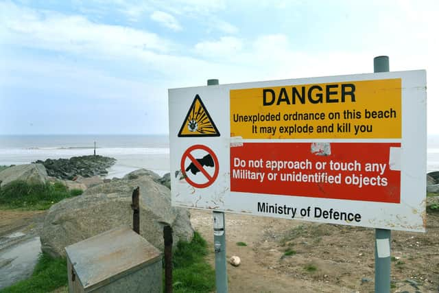
The biggest diversion is at Cowden where contractors continue the mammoth task of clearing hundreds of thousands of bombs fired for practice by tanks and aircraft.
Advertisement
Hide AdAdvertisement
Hide AdWhen the RAF took the site on in the 1960s static targets were set on the clifftops and later out at sea.
American A-10 Tankbusters would drop bellyfuls of ammunition, as did Phantoms, Buccaneers and Hawks. The site closed in 1998.
Those targets are now mostly on the beach and with them a huge amount of ordnance which can become exposed on the muddy shores. However Patrick Wharam, countryside access manager for East Riding Council, told councillors there’s a risk there could be unexploded ordnance on “any of that land where they haven’t hit the target”.
A low risk route had been agreed with the Ministry of Defence, skirting the western edge of the range, either immediately adjacent to the B1242 or agricultural land. The private company working on site will check the route to ensure it's 100 per cent safe for walkers.
Advertisement
Hide AdAdvertisement
Hide AdUnlike the Yorkshire Wolds Way which follows public rights of way, the coast path runs on access land.
"As the Holderness coast erodes, the path just rolls with it inland continually," he said.
"The vast majority of the land is private agricultural land. For most it's absolutely fine, it just keeps rolling.
"Sometimes it means it could come up to a caravan park or isolated farms or houses close to the edge, that might have an impact. But the vast majority of the route it will keep rolling back."
Advertisement
Hide AdAdvertisement
Hide AdSome new sections of footpath have been installed and to allow walkers to get across drains and ditches, 20 culverts will be installed, beginning this summer.
Three-quarters of maintenance funding will come from Defra, the rest from local government. Mr Wharam said: "Once it gets to the imminent risk area we will be moving culverts further back inland - that will be the ongoing project forever really."