Plans to build 360 homes on former Yorkshire RAF base which once stored Thor nuclear missiles


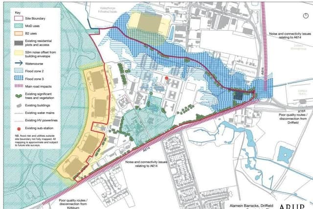
A draft masterplan has been published for Alamein Barracks, formerly RAF Driffield.
The site, under a mile from the town centre, was the base for RAF bomber squadrons during the Second World War and was later used as a Thor nuclear missile base.
Advertisement
Hide AdAdvertisement
Hide AdFor four years, at the height of the Cold War, Driffield was the regional headquarters for Project Emily, designed to inflict retaliatory mass-destruction on the Soviet Union.
A total of fifteen warheads were shared out between airfields at Driffield, Catfoss near Hornsea, Carnaby on the outskirts of Bridlington, Full Sutton, a few miles from York, and Breighton near Howden.
The majority of the 31-hectare site was sold by the Ministry of Defence (MoD) to Omnivale Ltd in 2007.
But the MoD has kept part of the site fronting the A614 for the regional cadet headquarters.
Advertisement
Hide AdAdvertisement
Hide AdThe four hangars to the west were sold off separately and are now used for employment, including manufacturing modular buildings.
Land beyond the hangars, including the former runways, is used “infrequently” by the MoD for driver training.
The draft proposals state that Alamein Barracks will be a “sustainable and contemporary residential community” set within a landscape of mature trees.
But it warns that there is a “medium probability” of coming across unexploded ordnance from World War Two.
Advertisement
Hide AdAdvertisement
Hide AdThey state: "Historical records indicate a medium level of bombing density across the borough in which the site was situated in WW2.
"The assessment has also identified a medium risk from German Unexploded Ordnance".
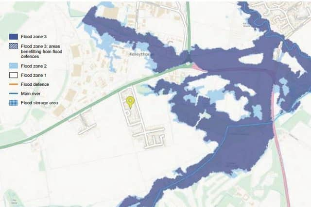
The Gypsey Race stream, which runs along the north-eastern boundary, offers “an opportunity to create a generous green corridor”, the documents state.
There has been a history of flooding in this section of the site, including to the rear of Montgomery Square/Gott Close and across Driffield Showground and Driffield Rugby Club in 2012.
Advertisement
Hide AdAdvertisement
Hide AdIt followed "exceptionally high flows in the Gypsey Race and backing up from culverted sections downstream to the east of the site", following "exceptional rainfall".
Three drop-ins are being held, with the first at Driffield Community Centre, Mill Street, on March 18, between 4.30pm and 7pm.
People can also email or write to East Riding Council by completing the response form or speak to a planning officer on 01482 391743.
Responses have to be in by April 24.
Comment Guidelines
National World encourages reader discussion on our stories. User feedback, insights and back-and-forth exchanges add a rich layer of context to reporting. Please review our Community Guidelines before commenting.