Point of no return?


But there was worse. When daylight broke, the Yorkshire Wildlife Trust – which has owned Spurn since 1959 – made a terrifying discovery. With stunning ease, the North Sea had actually remodelled the Yorkshire coast, moving part of the peninsula 80 yards to the west.
“I came down on the night of the storm and got as far as the village of Easington,” says heritage officer Andrew Mason, “and there was 3ft of water coming across the road even there. I thought: ‘Oh heck, Spurn’s gone’. Well, that didn’t quite happen, but there was a lot of damage.”
Advertisement
Hide AdAdvertisement
Hide AdThe far end of the reserve is now arduous to reach for visitors, who could once drive all the way down to the tip. Birdwatchers, in particular, love Spurn because of the famously vast numbers of migrating birds passing through each spring and autumn. Now visitors have a three-mile trek from the car park, and can only go at low tide. More importantly, though, the mutilation of the point’s defences has had an effect on vital services based on the peninsula. The loss of the road means that the lifeboat station, where the RNLI has its only full-time crew in the UK, is now isolated. Because of earlier erosion the crews had already sent their families packing. The damage has also forced Associated British Ports to relocate its vital VTS navigation service – which guides cargo vessels through the treacherous sandbanks of the Humber – from Spurn to Grimsby.


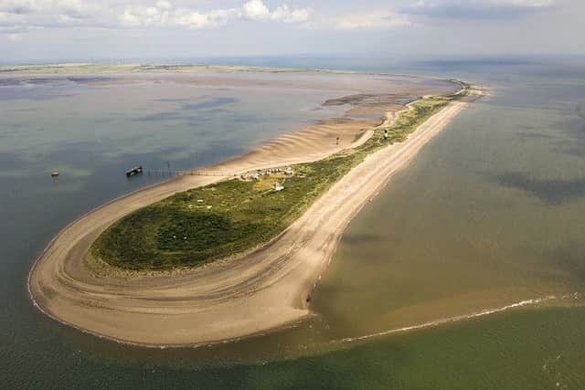
The Yorkshire Wildlife Trust, however, is nothing if not resourceful and has managed to turn adversity into a business opportunity, by attracting tourists on what it describes as Spurn Safaris. At low tide, Andrew – a former teacher – takes them on two-hour expeditions across the stretch of sand now known as the washover zone, starting his running commentary with the words “welcome to Britain’s newest island”.
It is not a fully formed island... yet. The mile-long strand of beach linking the two ends of the peninsula is submerged only when there’s a particularly high tide. Andrew makes a rough comparison with Lindisfarne off Northumberland, which is only accessible by a causeway at low tide. Although Spurn is still some way from being that cut off, he fears the washover zone may deepen in time, as happened in the 19th century.
It is certainly possible, because Spurn is the flimsiest stretch of coast in Europe. It formed at the end of the last Ice Age, when silt from the eroding cliffs of Holderness began to accrete on a small reef of rocks dumped by the melting glaciers. Ever since then, the spit of sand – shaped like a boomerang with a spoon at the end – has kept vanishing and reappearing, with silt torn from the Holderness coast always accumulating in slightly different locations. This natural cycle is thought to be triggered every 250 years, and until the breach in 2013 there were records of it happening three times since the Norman invasion. Geologists’ drawings of this now-you-see-it-now-you-don’t behaviour by Spurn look like time-lapse photography of a wagging finger.
Advertisement
Hide AdAdvertisement
Hide AdThe last major breach was in 1849 when a freak high spring tide ripped out a 12ft deep channel big enough for Humber fishing vessels to use as a short cut to and from the North Sea. It quickly became known as Chance Bay after boats came to grief in the strong tidal flow of six or seven knots through the gap and one fisherman was drowned. A second breach occurred a year later, and the earliest Ordnance Survey map for the Humber, published in 1852, showed Spurn as a small archipelago. It named the outermost of the string “Spurn Island”.


When that too started to erode, the Admiralty began to take a keen interest. Silt was in danger of accumulating in the Humber, which had become one of the great maritime hubs of the British Empire. It wasn’t only the gateway to the seaport of Hull, but also served as a lifeline for a string of inland ports along England’s river and canal network, including Nottingham, Sheffield and Leeds. Suddenly the deep-water channel, so vital to Britain’s trade, was at risk, and so the Admiralty decided to patch up Spurn by installing groynes to stop further erosion and building hard sea defences to close the gaps. The erosion continued, however, and there was yet a third breach. It took eight years for all the damage to be repaired.
But building those sea defences interfered with Spurn’s natural 250-year cycle, and in March 1978, The Yorkshire Post reported a study by Hull University, which concluded that the repairs had merely delayed Spurn’s habit of destruction and renewal. It was a century overdue, said scientists, and if ever the cycle was triggered again there could be serious consequences for shipping movements in and out of the Humber.
Today, the latest breach is being studied to see if that prediction might come true, since Spurn still offers physical protection to shipping lanes. Each tide pumps 1,500 tonnes of muddy sediment into the estuary, originating from erosion further up the Yorkshire coast, but without Spurn that figure would greatly increase and potentially create chaos for cargo vessels. The Humber ports handle goods worth more than £2.2bn a year, with Immingham on the south bank currently having the UK’s largest docks, while Hull is home to the east coast’s burgeoning offshore wind farm industry. Any changes to the Humber sandbanks could have a serious economic impact.
Advertisement
Hide AdAdvertisement
Hide AdTo those who visit Spurn – and they do so in increasing numbers – such warnings are of little consequence. Their main worry is that they now have to pay close attention to the state of the tide. Numerous signs warn them not to cross the washover zone at high tide, when the sea between the tip of Spurn and the mainland can be 4ft deep and there is a strong cross current. The signs describe the route as “extremely dangerous” and tell visitors never to walk through standing water or waves. For those who get stranded when Spurn is in its island state, an emergency shelter has been provided. And whenever there’s a spring tide and the water level rises, the Yorkshire Wildlife Trust mounts a patrol. “But,” sighs Andrews, “there’s always one idiot who is prepared to take a risk.” He tells of a visitor who tried to make the crossing despite being warned against it, and nearly came to grief.


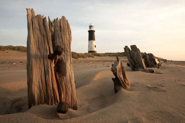
The trust’s Spurn Safaris have been a big hit with visitors. They climb onto a specially converted Unimog 4x4, bought from the Dutch army, and trundle across the washover zone to see the newly renovated Victorian lighthouse, climbing to its 128ft-high lantern room, and explore a warren of old Army gun emplacements dating from the First World War. The Unimog doesn’t attempt the trip if the water level is high, Andrew says, because wet sand has the consistency of porridge.
Pointing from the Unimog’s cab to where the road has collapsed nearer the tip, he says: “That’s another legacy of the 2013 storm. All of this eventually will collapse, but we don’t know when. It could be another ten years, or another twenty. There is no policy of defending Spurn against the sea now. We’re letting nature take its course.” He adds philosophically: “It may well be nature just doing its thing, making Spurn even more of a nature reserve.”
For further information on Spurn Safaris, including times and bookings, visit the Yorkshire Wildlife Trust’s website at ywt.org.uk/whats-on