Long and winding road around Yorkshire's coastal path


This cruel trick on walkers’ expectations will finally end on July 21, however, when a ribbon is snipped and a brand new stretch of public right of way is accessible as part of the 2,709-mile-long England Coast Path (ECP). A few strokes of a bureaucrat’s pen have opened up one of the best views on the Yorkshire coast, and one that’s bound to inspire a whole new range of postcards.
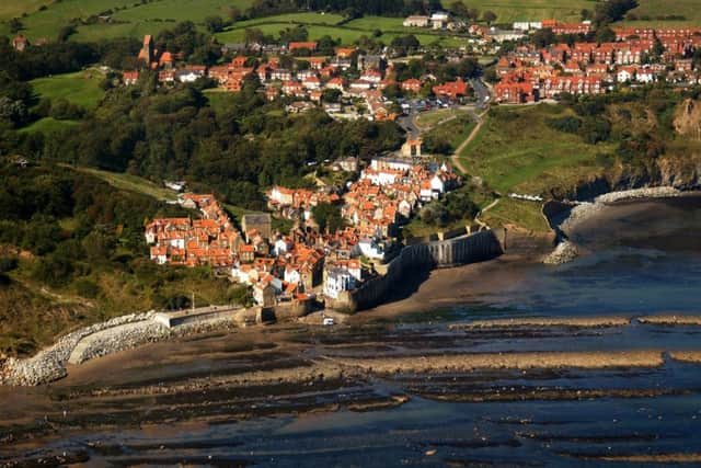
“It’s really spectacular,” says Andrew Best, of Natural England, who has spent over nine years planning the route’s east coast section from Skegness to the Scottish border. “From the new half a mile of public footpath that we negotiated with the landowners, the National Trust, you look straight down into Staithes harbour and across these rocky wave-cut platforms. It’s unbelievable.”
Advertisement
Hide AdAdvertisement
Hide AdThe latest stretch of the route to open runs for 68 miles from Filey to a road bridge over the River Tees at Middlesbrough. As the gull flies, the distance would be much less, but the path sticks to the coastline and where possible traces the edge of every bay.
Much of it is on existing public rights of way, and the 45 miles between Filey and the promenade at Saltburn-by-the-Sea will already be familiar to anyone who has walked the Cleveland Way around the North York Moors National Park. For the thousands of others who have yet discover the coast, though, among the treats they have in store are the superb long-distance views across Runswick Bay from Kettleness and the dramatic reef of Saltwick Nab to the south of Whitby.
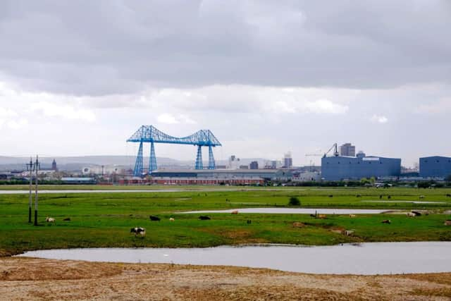
Further north, several new rights of way will finally be open to walkers along the Redcar and Cleveland coast – which was part of Yorkshire’s North Riding until 1974 – as well as a couple of steel footbridges. However, the iconic Transporter Bridge across the Tees will not be used to join the path’s continued journey up the coast of County Durham because of its limited opening hours.
The route’s main problems have been further south, however. A survey by Andrew Best’s team identified 18 gaps that needed to be plugged in order to create a continuous footpath from Filey to Bridlington. Work on that is now more or less complete, with a particularly lovely new path routed along the edge of the old Butlins holiday camp and through a wooded valley above Speeton Sands.
Advertisement
Hide AdAdvertisement
Hide AdThe most difficult part of the Yorkshire coast to forge a route has been the 35 miles of cliffs between Bridlington and Spurn. This suffers from the worst erosion in Western Europe, with as much as seven feet of clifftop a year crumbling into the sea. Footpaths which once existed here long ago vanished off the map, along with entire villages.
“That area is quite a challenge for us,” Andrew admits. “Two of my colleagues are writing a report on it as we speak, and it’s been a long and tricky operation. However, there has been a tremendous amount of goodwill from the landowners and we’ve potentially got the line of the path there just about ready.”
Routing it along the Holderness coast would have been impossible without the legislation that created the ECP providing a special measure called “roll back”, designed to establish the principle of a legal right of way surviving even when coastal erosion washes away the physical footpath. When the path disappears, the right of way simply rolls back to the next available strip of land on which to establish a 12ft wide walking route.
Previously, erosion of footpaths on the Yorkshire coast has meant years of disruption. When one clifftop path crumbled at Robin Hood’s Bay it was a decade before a new right of way could be established. Now such problems can be solved within weeks or months.
Advertisement
Hide AdAdvertisement
Hide AdAnother new principle established by the coastal path is the idea of something called “spreading room”. This provides the right-to-roam similar to that which now exists in many upland areas, giving people legal access to anywhere between the path and the low-water mark.
Not surprisingly, the RSPB and the Yorkshire Wildlife Trust raised concerns about this aspect of the path because it seemed to give climbers the legal right to abseil down the 300ft high chalk cliffs round Bempton and Flamborough, where tens of thousands of seabirds nest every year. But it has been made clear that the “spreading room” concept will not compromise anywhere that is protected for nature conservation. Nor will it give walkers the right to trample over domestic gardens and wander around defence installations.
Bit by bit, new stretches of the coastal path have been unveiled since the first was opened at Weymouth Bay in 2012 to provide a viewpoint for the 2012 Olympic and Paralympic sailing events. However, before this month’s opening in North Yorkshire, the only section completed north of The Wash was a 34-mile path between Hartlepool and Sunderland.
In some areas, the new path has brought about a welcome increase in visitor numbers and shot in the arm for the beleaguered English seaside economy, with farmers opening campsites and more bed and breakfast bookings. At Trimmingham in north Norfolk, for instance, a counter that records the number of people using a stile tallied 2,036 walkers in the spring of 2014, but after the path opened last year the number rose to 3,097. To cash in, local people banded together to open a community cafe.
Advertisement
Hide AdAdvertisement
Hide Ad“There is something about the sea and coast that draws people,” says the path’s programme manager for Natural England, Neil Constable. “And where stretches of the route have already opened we are seeing increased visitor numbers like they have at Trimmingham. It’s the start of something that is very exciting. Whilst we are still some way off the completion target in 2020 it’s already clear that the English Coast Path is going to be a fantastic asset to our country.”