
Bradfield, South Yorkshire: The highs and lows of twin villages
Just six miles from one of the world’s foremost industrial cities, the South Yorkshire villages of Bradfield are among the most popular destinations in the Peak District National Park.
Despite its proximity to Sheffield, Bradfield feels a world away in its isolated position in the Loxley Valley. People travelling to and from Bradfield using the nearby trans-Pennine routes of the A57 and A616 have to negotiate narrow, winding, unclassified roads across open gritstone moorland and steep-sided valleys.
Widely collectively known as Bradfield, Low Bradfield is where the Agden Beck and Dale Dike meet, while High Bradfield is set high above the valley on steeply rising millstone grit slopes. They are geographically distinct settlements.
The villages are separated by a hill so steep cyclists argue over its gradient. Wood Fall Lane, which starts beside the picturesque cricket ground in Low Bradfield, is thought to rise by almost 1:4 in places, placing it among Yorkshire’s toughest bike ascents.

Dubbed the Côte de Bradfield, the subsequent climb out of High Bradfield featured as a challenge close to the climax of Stage 2 of the 2014 Tour de France.
Local cyclists insist the Tour de France section of the climb is the easy bit.
At the base of the hill, overlooking Bradfield’s cricket pitch, the Cricket View Cafe and Shop has proved a draw for walkers and cyclists as well as forming a key community venue.
The villages have vastly different origins as well. Withstanding the shared name, which was adopted in relatively modern times, Low Bradfield used to be known as Netherton and High Bradfield as Kirkton of Bradfield.
Low Bradfield developed as a farming community, with most of the surrounding land set aside by Norman Lords as a deer hunting park, around a manorial corn mill on the banks of the River Loxley.
Documents have shown how part of the mill was given to the Priory of Worksop in the early 13th century and others record how it remained operational several centuries later.
The mill is thought to have stood close to School Bridge, on the same site of a three-storey corn mill from the 16th century and near a fee-paying endowed school in School Lane, established by Lord of the manor and dissenter Sir Thomas Marriott of Ughill in 1706.
The corn mill, bridges and a replacement school building in Low Bradfield were swept away in 1864, in one of the worst man-made disasters in British history, when the newly-built Dale Dike Dam wall failed.
Some 650 million gallons of water gushed down the Loxley and then Don valleys, before destroying properties in Sheffield and claiming the lives of about 240 people.
A Government inspector later concluded: “Not even a Derby horse could have carried the warning in time to have saved the people down the valley.”
A smaller reservoir was rebuilt about 300m upstream 11 years later.
While there are several Bradfield Scheme reservoirs close to the villages, trees also feature significantly in the landscape surrounding Bradfield in clusters, wooded cloughs and scattered along field boundaries. The rural character of the villages is further enhanced by most of Bradfield’s cottages and farmhouses being built from local gritstone with stone slate roofs, dating from around the time of the Industrial Revolution.
Bradfield has two of the 109 conservation areas in the national park, meaning its built heritage has benefitted from layers of protections as well as grants available for the repair and reinstatement of external architectural features to both listed and unlisted buildings and stone boundary walls.
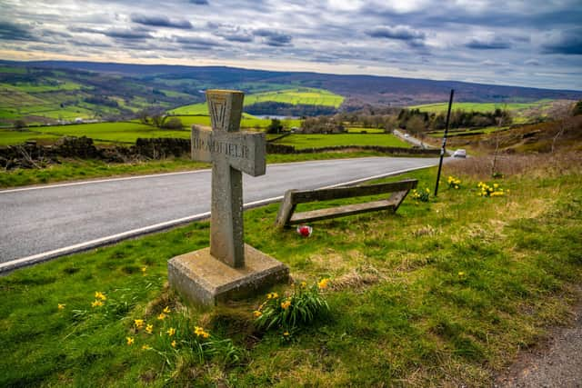
Nevertheless, Anglo-Saxon place names such as Ewden, Bradfield and Agden in the vicinity suggest a settlement may have been established in Bradfield before the Norman conquest, a theory strengthened by the tenth century Saxon stone way-maker cross found in a Low Bradfield field in 1886.
High Bradfield was born in the early 12th century when the Manor of Hallamshire passed to William de Lovetot, who built the first motte and bailey castle in the Sheffield area. It is thought may have served as base from which Sheffield Castle controlled the Hallamshire moorland. Another nearby mound is thought to have been an ancient burial ground and place of worship.
The sites, protected as scheduled monuments, are about 100m to the west of St Nicholas’ Church, which largely dates largely from the 15th century. However, two pillars bases date to the Norman era. The grade I listed place of worship forms a popular backdrop for the annual week-long Bradfield Festival of Music, to be staged from June 20.
Charitable church body the Bradfield Feoffees has made grants to the poor of the parish since the 15th century. It administers 17 historic and listed buildings and, including those in the triangle of High Bradfield formed by Brown Lane, Jane Street and Towngate. Also on Towngate, Wesley Cottages formed part of a workhouse from the 18th century while The Stables once served as a hearse house.
Beside the church cemetery and Jane Street stands a circular stone building with numerous windows built in 1830 to shelter people watching for thieves stealing bodies to sell for medical research. It is Yorkshire’s last remaining watch house. Towngate features The Old Horns Inn, which when it opened in 1833 served as an “inn-cum-farm”, with a cowshed, stables pig sties and barns. It’s renowned for having spectacular views across the Loxley Valley from its beer garden.
It is said farm hands gathered outside the pub on the last Friday in October for hundreds of years, wearing plated straw on their jackets to indicate the job they did, in the hope of being hired, with contracts being sealed through hand-slapping or fastening penny payments.