
Kirkby Overblow: A village forged by its wind and iron
Once a centre of heavy industry, the chirps of songbirds mixed with the low hum of traffic passing along the Harrogate bypass and Leeds road could hardly contrast more with the roar of the wind-powered furnaces that gave the medieval village of Kirkby Overblow its name.
A corruption of Kirkby-Ore-Blowers, it was named due to the profusion of smelters once operating around what now forms a tight-knit community of about 300 residents huddled together in a nucleated settlement 400ft above sea level.
Following analysis of historic slag samples, academics have concluded Kirkby Overblow’s iron processing was quite effective despite large amounts of iron oxide seemingly sacrificed in the smelt.
The remains of cinder beds in the area have also indicated that trees were used and wind furnaces were moved to be nearer their fuel source, but other than the village entrance signs, little evidence of the industry remains today – understood to have moved away from the village in the 15th century as small, batch-based bloomeries were superseded by water-powered blast furnaces.

However, just to the south of Kirkby Overblow’s small but perfectly formed playground, in an arable field off Barrowby Lane, remain cropmarks of at least three sub-rectangular enclosures.
They are believed to have formed part of the lost medieval village of Tidover, where controversial cleric St Wilfrid of Ripon is said to have performed a miracle resuscitating a boy during the late 7th century.
With links to the cult of saints, the village became a centre for Wilweorthunga or well worship due to the array of springs around Kirkby Overblow. There are understood to be about 40 springs and wells in the parish.
Dating from the fourth century, the clear St Helen’s Well waters flow out of the bank just west of St Helen’s Cottage on Swindon Lane into a stone trough in a low, walled chamber.
A guide to All Saints’ Church, which overlooks the well, reveals how during pre-Christian times, the well would have been a focus for fertility rites. Significantly, there is a track leading from the well to Almscliffe Crag, another pagan place of worship.
A short walk further along the lane, Bird Well flows into a large stone trough, and also to the west of the village, only a stone’s throw south of Walton Head Lane, along the ancient church way between Rigton and the village, the waters of Wareholes Well, drop into a deep trough below a five-foot boundary stone inscribed with the date 1767, which some have suggested is a prehistoric standing stone.
While the early Church consecrated pagan holy wells, well worship would eventually be outlawed by Edgar the Peaceful, the king of Mercia and the Danelaw, in 959. A fragment of Anglo-Scandinavian stonework has been unearthed during works at All Saints’ Church, but the current building was reconstructed in 1780.
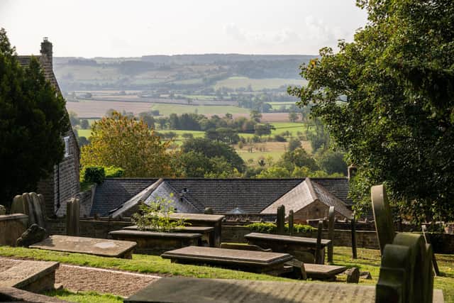
Sited on the south-facing ridge’s highest point, it features a three-stage tower, a 14th-century north transept, a north wall with two windows with plate tracery from that era and a blocked Saxon entrance with a round head close to its west end.
Due to the lack of community space in the village, the church has doubled as a village hall and has been a venue for concerts and Kirkby Overblow Dramatic Society.
Aside from the walled graveyard, rather than significant public open spaces, Kirkby Overblow features green spaces between properties with expansive back gardens, which, with many far-reaching views, gives the village an open, rural feel, as do its converted former agricultural buildings such as those at Laurel Farm on Walton Head Lane and Sycamore Farm House on Main Street.
On the north side of Barrowby Lane, the 17th-century Field House farmhouse has an attached outbuilding featuring a central first-floor door reached by a flight of stone steps.
The farm was owned by Coverdale cheese producer Alfred Rowntree.
One of the best views is from a 1930s development of detached houses on the site of a former quarry on Barrowby Lane, from where dozens of miles of the Vale of York can be viewed, from the White Horse of Kilburn to the North York Moors.
From points in the village it is also possible to see the York Minster, and even the Yorkshire Wolds are visible on a clear day.
Much closer, to the west, landmarks include Almscliffe Crag, the Chevin and Ilkley Moor.
The church is among a small group of attractive listed buildings in the core of the village, around the crossroads of Follifoot, Barrowby, Swindon and Orchard lanes, which also include a Georgian rectory and cottages from the period.
From the 18th century, the village’s northern arm, Follifoot Lane, featured two inns.
While the three-storey Star & Garter closed in 2018, the ivy-covered Shoulder of Mutton is open for nearly 80 hours a week and draws diners to the village as well as serving villagers with a rotating selection of real ale.
Opposite the inn there’s an unusual bus shelter, built into a boundary wall and featuring an arched opening, built by the community to commemorate Queen Elizabeth’s coronation.
Community leaders have voiced optimism about the future of the former Star & Garter building as bed and breakfast accommodation, with the main ground floor area being made available for community use.
Kirkby Overblow has held on to its Church of England primary school, which is also on Follifoot Lane, which in 2013 was named the highest achieving in North Yorkshire when all its Year 6 pupils achieved at least a level 4 in reading, writing and maths, with 55 per cent achieving level 5 or above.
A recent inspection found it to be “full of love and joy” and that the school’s ethos is strongly felt throughout the community.