Thorne might be flat, but it has lots of high points


Just ten miles from Doncaster, Thorne is a town with a changing population that has risen and fallen in tandem with its fortunes.
Although its recent history has been closely intertwined with the growth and subsequent demise of South Yorkshire’s coal mining industry, the town can trace its origins back much further. Thorne has been a permanent settlement for 13 centuries, but archaeological finds from the area suggest that it was inhabited as far back as the Bronze and Iron Ages.
Advertisement
Hide AdAdvertisement
Hide AdAround the time of the Norman Conquest, the Lord of the Manor of Thorne was William de Warenne, a Norman nobleman who built nearby Conisbrough Castle. In the late 11th century, a motte and bailey castle was built at Thorne. Peel Hill Motte – the mound of earth on which the castle once stood – is all that remains of it today. A scheduled monument, it’s located off Church Street and is open to the public. As Thorne was once located within Hatfield Chase, a vast royal hunting ground, it’s likely that the castle was originally used as a hunting lodge. However, it was also used as a prison where those caught poaching would be held before being sent to York for trial. Sadly, the castle was demolished during the 17th century.
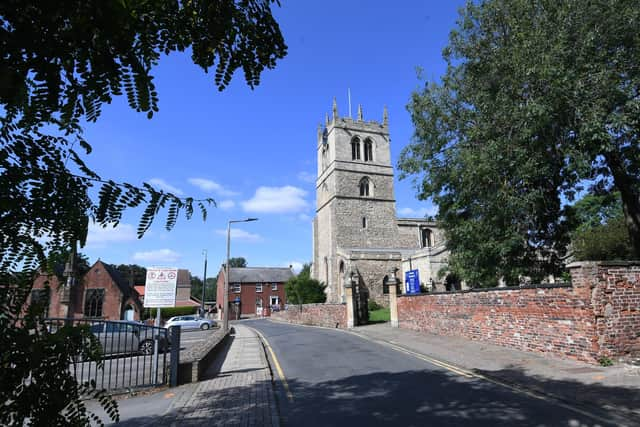
Located nearby, St Nicholas Parish Church is a Grade II-listed structure dating back to the 12th century, which was built from the same magnesian limestone as the castle. During the medieval period, homes were clustered around modern day Church Street and the Market Place because much of the surrounding area was made up of swampy marshland unsuitable for development. Held at the National Archives at Kew, the Inclesmoor Map, which was created around 1407, shows the area of land bounded by the rivers Aire, Ouse, Trent, Don and old Don, as well as the vast expanse of land known as Thorne Moor and Goole Moor. Marked upon the map and mentioned by name, albeit in old English, are many of the towns and villages that we know today, including Thorne. According to Chris Collins, a volunteer at Goole Museum, the map was drawn up to settle a dispute over access to the moor.
She explained: “In the century before the map was created, there had been lots of land disputes, often involving the monasteries. Having been deforested in Roman times, much of the area shown on the map was boggy peatland and the monasteries wanted the peat for fuel. The map was found among the papers of the Duchy of Lancaster and was created to settle a land dispute with St Mary’s Abbey over rights to pasture and peat.”
Today, Thorne Moor, together with Goole, Hatfield and Crowle Moors, forms part of the Humberhead Peatlands, the largest area of raised bog wilderness in lowland Britain. At 2,887 hectares in size, the site is of international importance as an example of a lowland raised mire and for its breeding population of nightjars. The Humberhead Peatlands are remnants of a large wetland that occupied the floodplain of the Humberhead Levels thousands of years ago. Thorne and Hatfield Moors were both exploited for peat over many centuries but, during the 20th century, the bog and its biodiversity were severely threatened by mechanised peat extraction. These activities ceased in 2004 and work to restore the UK’s largest area of degraded lowland raised bog began. Now a nature reserve, Thorne Moor is open to visitors, who can enjoy a choice of different walking routes and the opportunity to spot rare plants, insects, fallow deer and adders.
Advertisement
Hide AdAdvertisement
Hide AdThe drainage of thousands of acres of wetland during the 17th century by Dutch engineer Cornelius Vermuyden changed the face of the Thorne area forever. Charles I granted permission for the land to be drained in 1626 and Vermuyden is said to have lived in Thorne for a time as he oversaw the work. Although many Thorne residents were opposed to the scheme and a number of serious flooding incidents are said to have occurred afterwards, the value of the land increased dramatically as it became suitable for agriculture and many farms were built in the centuries that followed.
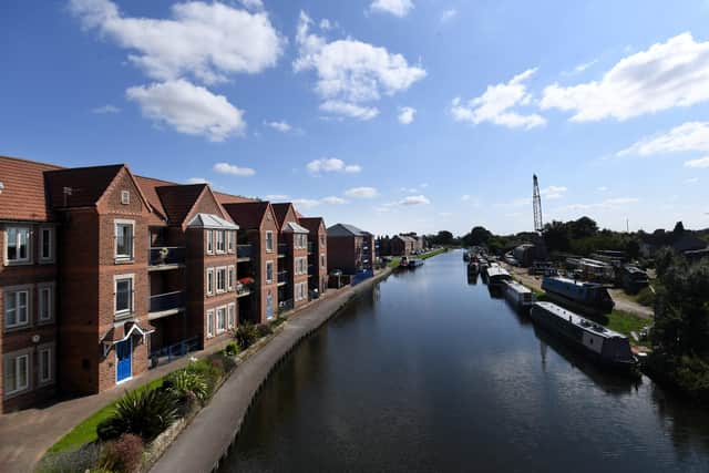
Meanwhile, as the shipping trade on the River Don expanded, ship building yards sprang up in Thorne, as well as warehouses, inns, and rope and sail-making businesses. The town’s population quickly grew and the opening of the Stainforth and Keadby Canal, which connects the River Don Navigation to the River Trent, in 1802 brought further prosperity to the area. Today the canal side and Thorne Lock are among the most picturesque parts of the town, and, although the large ship building firms are long gone, Staniland Marina is home to around 85 pleasure boats.
The opening of Thorne Colliery in 1925 brought an influx of people to the area and the village of Moorends, which forms part of the parish of Thorne, sprang up to house them, along with some of the town’s large council estates. Part of the South Yorkshire Coalfield, the colliery closed for good in 1956, having been beset by a series of flooding problems and other operational issues, which meant that it was unproductive for much of its lifespan. Despite a series of unsuccessful proposals to resume production during the 1980s and 1990s, the pit’s headgear was demolished around 2004. For a time, the colliery was the area’s biggest employer and many people living in Thorne and Moorends today have a connection with it. The death of the mining industry was a hammer blow to local communities and, in the years that followed, Thorne and Moorends attracted government funding aimed at tackling unemployment, social deprivation and health inequalities.
It would be remiss to write about Thorne without mentioning a couple of its famous sons and daughters, who include the opera singer Lesley Garrett; the sculptor Byron Howard, whose studio can be found on Church Street and is sometimes open to visitors; and, of course, the legendary Thomas Crapper, who famously invented the toilet, or W.C. (water closet). Manhole covers in Westminster Abbey featuring Crapper’s company name have become one of London’s minor tourist attractions.
Advertisement
Hide AdAdvertisement
Hide AdThanks to Vermuyden, Thorne is sometimes referred to as Little Holland. The flat landscape makes for easy walking and the Thorne Town Trail takes in many of the town’s most interesting features. Tourist information leaflets are available free of charge at the Town Council’s offices in the Assembly Rooms on Fieldside.
Popular places to visit include the Community Woodland near the canal and Thorne Memorial Park, where there’s a lake suitable for model boats, a miniature steam railway and a bandstand, which sometimes hosts free concerts.
Comment Guidelines
National World encourages reader discussion on our stories. User feedback, insights and back-and-forth exchanges add a rich layer of context to reporting. Please review our Community Guidelines before commenting.