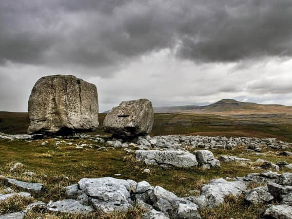
Picture Post: The Cheese Press Stone shows how Yorkshire Dales landscape was shaped by the Ice Age


The limestone boulders date back to the Ice Age and are now part of the stunning local landscape in this particular area, which offers excellent views of two of Yorkshire’s Three Peaks, Ingleborough and Whernside, as well as other limestone features like caves.
Back in 2018, researchers at Sheffield University created an interactive online map showing how the nation was affected by the last glacial cycle 22,000 years ago, when a half mile-thick sheet of ice covered Britain.
Advertisement
Hide AdAdvertisement
Hide AdSpeaking at the time, Dr Jeremy Ely, of the university’s geography department, explained: “The landform information tells us about how the last British-Irish ice sheet behaved. We can see how it dammed rivers, creating large glacial lakes which covered Manchester, Doncaster and Peterborough. Corridors of fast flowing ice, flowed toward the east over Edinburgh and toward the west over Glasgow. Ice also covered Ireland, flowing through the Irish Sea, where it coalesced with Welsh ice, causing it to flow southward to the Isles of Scilly.”
Much of the stunning landscape of the Yorkshire Dales is made from limestone which was exposed by the process of glaciation during the last Ice Age. When the glaciers melted, the resulting water is believed to have helped form the dales that make up the area. There is also an underground impact thanks to the limestone with some of the most extensive cave systems in Europe found in the area.
As the Yorkshire Dales National Park Authority website explains: “Our stunning landscape was shaped over millennia by ice. This created a rolling landscape of lush dales, windswept hills like the famous Three Peaks and vast expanses of heather-covered moors. Over the centuries, people’s interaction with nature has produced countryside of incredible beauty.”
Technical Details: Nikon D6 camera, 24-70mm Nikkor lens, 1/100th second at f8, ISO 400. Picture by Bruce Rollinson
Advertisement
Hide AdAdvertisement
Hide AdSupport The Yorkshire Post and become a subscriber today. Your subscription will help us to continue to bring quality news to the people of Yorkshire. In return, you'll see fewer ads on site, get free access to our app and receive exclusive members-only offers. Click here to subscribe.