
‘Imminent collapse’ or ‘hoo-ha about nothing’: The cliff top road in danger of dividing a community
A council says it is carrying out weekly inspections of a coastal road subject to cliff top erosion and the safety of residents is its number one priority.
Redcar and Cleveland Council is speeding up plans to realign Cowbar Lane, in Cowbar, near Staithes, which an adopted coastal management strategy has suggested should be moved sequentially away in three stages from the cliff edge southwards.
Phase one of the engineering works, which could cost £1.2m, was not due to start until the early 2030s, but after updated advice was received by the council which revised future erosion predictions, the aim is to deliver it “as soon as possible” by 2027.
Some residents in the small village have questioned the local authority plans, which involve the purchase and demolition of a cottage in order to re-route the road which leads down to the harbour at Staithes.
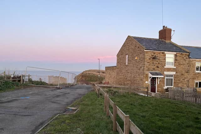

Negotiations have been undertaken with the owner, with the council also seeking funding to cover the first phase costs from external partners such as the Environment Agency.
After a rock fall incident in October 2024 the council has termed “significant”, caused by a continued combination of crashing waves up to 30 metres high and heavy rain, consultants Royal Haskoning/DHV were hired to determine the effect on the lane.
Academics from Durham University have also been involved in monitoring sections of the coast in the area, applying advanced techniques such as 3D laser scanning to understand and predict future erosion.
The cliffs at Cowbar contain soft glacial till along with sections of sandstone and shale lower down, while rock armour from Norway has been used to shore up their base.
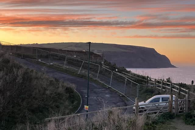
Previous stabilisation measures have also sought to protect the upper till layer, but are said to be no longer providing any support.
Another factor being considered is rising sea levels, caused by global warming.
Findings from Haskoning, which extrapolated a long term average of 0.1m of the cliff eroding each year, led to a prediction of a potential “imminent collapse” of the cliff edge at Cowbar Lane, prompting the council to put up heras fencing panels in May to stop vehicles parking in a layby at the crest of where the slip took place.
A spokesman for the council further explained: “There is a buffer zone from cliff face to the edge of the carriageway.
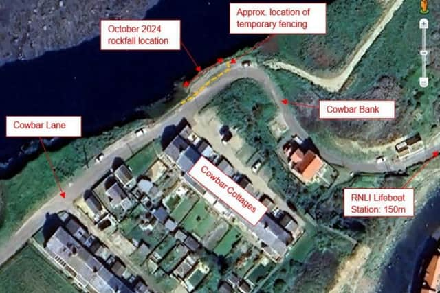
“However, should we witness a further significant rock fall this may impact on the buffer zone with the possibility of beginning to encroach on the road and at that stage we would assess the situation and consider future vehicle access. Weekly inspections of the road continue to be undertaken.”
The Local Democracy Reporting Service (LDRS) asked the council how value for money would be achieved with the property purchase required for the initial scheme.
The spokesman said council officers had “negotiated a price which is reflective of the current market value for properties of this type in the Staithes area”.
He said: “The transaction remains subject to final council approval before the acquisition can be completed and will be funded as part of the overall scheme of development.”
The firm AtkinsRealisUK has been tasked by the council with shaping the design of the realigned road, along with advising on the required relocation of any utilities.
The construction period has been estimated at eight months.
The spokesman added: “In accordance with the strategy, the results of monitoring work [will] be continually reviewed to inform a continually evolving risk assessment at Cowbar Cottages with the recommended works being accelerated, altered or paused should findings suggest a change to erosion predictions.
“Safety and access for residents and road users is our number one priority in delivering the proposed works.”
Cowbar Lane provides the only vehicle access to a Yorkshire Water pumping station close to the harbour and a RNLI lifeboat station, while further properties are dotted along Cowbar Bank which use the route for access.
Loftus ward councillor Tim Gray, whose patch takes in Cowbar, said the council had to consider the “here and now” and he wanted to see the works planned carried out sooner rather than later.
He also said the council could not “just abandon the road”.
A steering group has been set up consisting of council representatives, people living locally and other stakeholders, and is meeting regularly to discuss the project.
A presentation given to one meeting said a phased road realignment remained the “most economically viable” and “environmentally preferred” option with nearby cottages being retained longer than in a “single intervention”.
The council has escalated the issue of coastal erosion as a corporate “red risk” with a report for councillors stating this includes the risk of legal challenge in relation to its responsibilities and the “reputational risk from perceived inaction or response”.
At the scene
“It’s a lot of hoo-ha about nothing”, one resident tells me after I arrive in Cowbar Lane mid-afternoon.
Behind me is the imposing backdrop of the huge Boulby potash mine, which dominates the local landscape, with the mighty North Sea straight ahead.
Cowbar Lane weaves its way along the cliff edge, while a small hamlet of houses sits off it to the right.
Keep going and the lane curves around a bend which takes you down eventually to the harbour in the once bustling fishing port, picturesque Staithes.
Metal fencing can be seen along the lane and beyond it the outline of a previous route it took with a few stone-like remnants remaining of a long-gone property which once overlooked the cliff and the sea.
Having knocked on his door a few moments earlier, the resident grabs his coat and kindly offers to accompany me to the scene and share his thoughts.
He says: “I have lived here 25 years and the cliff might have gone back a metre in that time.”
He is plainly of the view that the work as proposed is not required, and has less than complimentary things to say about the council, adding: “If it’s that bad [the coastal erosion] why are they still letting traffic and vehicles come down here?”
There is a decent sized distance from the cliff edge and the property which is in line to be demolished to realign the lane, that much is obvious.
But mine is only a layman’s eye and it’s hard to predict to what extent mud and rocks will be sent falling, and when, and further cut into the landscape.
The terraced property in line to be knocked down has an extension out the back where once an outside toilet block would have been and a modern looking refurbished exterior.
No one appears to be in with neighbours stating it is used as a second home.
A woman I also speak to confesses there is anxiety in the community over the evolving picture, but is reluctant to discuss matters further.
Another long-standing householder, Colin Mann, who says he has been in Cowbar for 50 years, previously formed a local residents association which secured grants for the area and also commissioned a Durham University study in 2006 which considered the estimated rate at which the coast was retreating.
It said the position of future cliff lines was of “utmost importance” and would have a significant, immediate and long lasting impact on residents.
Mr Mann, a local landowner, refers to vested interests, explaining at length disputes he has been involved in with the council.
In follow-up emails continuing our exchange, he says he does not have “technical answers”, but queries whether it is possible the rock armour in the shape of a ‘revetment’ – a sloping structure built along shorelines in order to dissipate wave energy – installed back in 2007 may have in fact had a “negative result on cliff stability”.
He claims at that time there had been little regression of the cliff for the previous 100 years.
Mr Mann also advises that there are “diverse attitudes with equal validity” in the local community and “you will have to rely on your skills to unravel what is pertinent”.
What is pertinent is that neither the North Sea or the dozens of residents who have made their home here are going away and something will have to give, it’s just a question of time.