Next 24 hours could be wetter than whole of July - aren't you glad you're in Yorkshire? (But best take your brolly)


August will get off to a chilly, bright start in the North with rain over significant parts of the South feeding into a changeable seven days, the Met Office said.
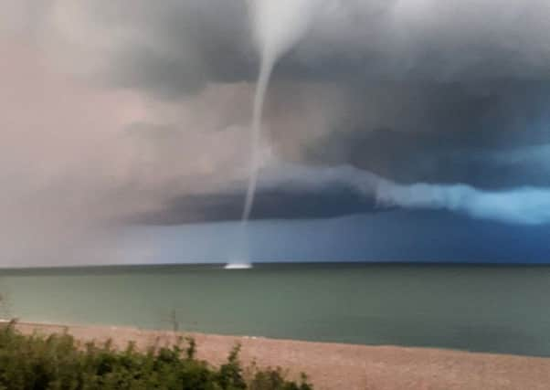
The mixed forecast comes one day after a water spout was spotted at Thorpeness descending from dark clouds looming over the Suffolk coastline.
Advertisement
Hide AdAdvertisement
Hide AdPictures captured by onlookers show the swirling funnel spinning through the waves. Forming over water, the feature is rarely spotted as the tornado appears over the sea, with around 100 of them occurring annually.
A Met Office forecaster said: “July was obviously very, very dry, across parts of south-west Britain in particular, so there is a good chance we could see more rain across parts of the South West in the next 24 hours on Monday than we’ve seen in the entire month.
“It will be a real topsy-turvy week - no two days quite the same. But in the next five to seven days we will all see some rain at times - useful rain for those who have got parched gardens; obviously not great for those under canvas or trying to enjoy the beach.”
While sun-lovers hoping for a lengthy heatwave in the next fortnight may be disappointed, the month should avoid being a washout.
Advertisement
Hide AdAdvertisement
Hide AdMoving into the second week of August, the further north-west parts of the UK the greater chance of seeing rain and stronger winds, while the South East will be generally a bit drier with a greater chance of seeing more prolonged periods of sunshine and high temperatures.
People can expect temperatures of low 20Cs in the South, and high teens in the North - “not a washout by any means, but again not exactly blazing summer either”, the Met Office said.
The best chance for a settled, warm period will be early on in the second half of August, particularly in the South, but the Met Office warned there was “certainly no strong signal for any prolonged period of hot weather” at the moment.
“We saw how quickly in July it can turn hot for a day and then be all gone the next; it’s not completely ruling out some hot summer weather but it’s unlikely to be long-lived event if it was to come off,” the forecaster added.
Advertisement
Hide AdAdvertisement
Hide AdThe Isle of Wight saw its driest July on records, with only 1mm (0.04in) of rain falling over the month.
However, the start of August brings a change in weather, with up to 20mm (0.8in) of rain expected over the next 24 hours.
A second Met Office forecaster, Simon Partridge, said: “According to records it is certainly the driest July on the Isle, certainly at St Catherine’s Point.
“But there is rain on its way - a weak little band of rain that has already crossed most of Cornwall and Devon.”
Advertisement
Hide AdAdvertisement
Hide AdMeanwhile, Coral has cut the odds on this August being the hottest on record from 5-1 to 3-1, amid a flurry of bets that Britain will bask in a heatwave before the month is out.
FORECAST SUMMARY FOR YORKSHIRE
Monday
After a rather chilly start it should be a dry morning with some sunny spells. Rather more cloudy at times in the afternoon, perhaps with the odd light shower developing.
Tonight
After a dry start, thicker cloud will bring outbreaks of rain from the west through the evening, mostly to the south of the Humber, but becoming dry again after midnight.
Tuesday
A dry morning with a few bright or sunny intervals, but thicker cloud will bring patchy rain in the afternoon, and some more general rain to the west by evening.
Wednesday to Friday
Bright or sunny spells and scattered showers, these perhaps more frequent and locally heavy on Thursday but fewer by Friday. Windy at first, but winds easing through Thursday and Friday.