York braced for the worst as river levels continue to rise


The group comprises representatives from City of York Council, the Environment Agency, North Yorkshire Police, North Yorkshire Fire & Rescue and Yorkshire Water.
It only meets when the River Ouse levels reach, or are expected to reach, 4.2 meters above normal summer level (asl). River levels are currently at 3.8m asl and are predicated to peak at 5m asl Monday afternoon.
Advertisement
Hide AdAdvertisement
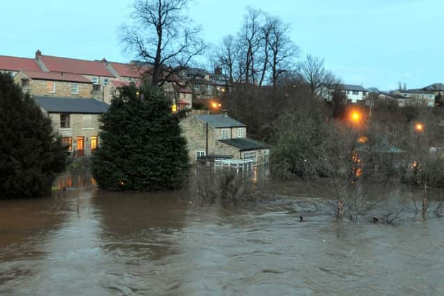
Hide AdSevere flood warnings have been issued for the city, on the Foss at Huntington, York, Huntington Road and Foss Islands; and Osbaldwick and Tang Hall becks, while the Scarborough and Ryedale Mountain Rescue Team has been deployed to York, it announced at 9.45pm.
Police say as many as 3500 properties could be in involved, and an Environment Agency spokesman has said both York’s rivers are not expected to peak until Monday.
The Environment Agency has told people in those areas to move their valuable belongings upstairs and to prepare for evacuation.
Charlie Croft, of City of York Council, said they were “in uncharted territory” after the River Foss pumping station failed and the Foss barrier had to be opened. The barrier was lifted on Saturday evening after water entered the barrier’s building. A Tweet from the agency confirmed that it had been lifted and that it would cause risk to city centre of Huntington, Tang hall, Osbaldwick & Foss Islands.
Advertisement
Hide AdAdvertisement
Hide AdCurrently, due to the high river levels, Rowntree Park and St George’s Field Car Park are closed. Roads have also been closed, including the A64 eastbound between Copmanthorpe in York and Brambling Fields Junction in Scagglethorpe.
A rest centre has been set up at Archbishop Holgate’s School for people in Tang Hall and Huntington Road areas.
Current road closures in York, include:
• Huntington Road – from the Monkgate roundabout and Hayley’s Terrace/Fossway Junction
• Monks Cross Link Road
• Rufforth Main Street
• Water Lane
• Foss Bank (Near Go Outdoors)
Bus sevices on these roads may be affected on Sunday and people are advised to contact the bus operator in the first instance. All Park&Ride routes will be running as normal tomorrow. Diversions may be in place which may result in slightly longer journey times.
Advertisement
Hide AdAdvertisement
Hide AdResidents living in City of York Council’s Windsor House residential home are being reloacted within other council owned residential homes. This is due to minor flooding in the basement of the buidling. Families are being directly informed.
City of York Council has erected sandbag defences at Peckitt Street, Tower Gardens, Tower Place and Clementhorpe. The access bridge to City Mills Residential Home has also been erected.
Front line teams from all organisations are working round the clock to protect residents, tourists and to keep York open for business.
Nearby Boroughbridge and Wetherby were also badly affected as the river levels continued to rise.
Advertisement
Hide AdAdvertisement
Hide AdA joint “silver command” with police, fire and rescue, and other agencies is being set up at Fulford Road Police Station.
The Wharfe has also burst its bank and evacuations are likely in Tadcaster.
The Environment Agency is monitoring the situation. The Environment Agency Floodline number is 0345 988 1188 or visit http://apps.environment-agency.gov.uk/flood/31618.aspx