
12 winter walks where you can take in the sheer beauty of Yorkshire
Roger Ratcliffe takes us through 12 wintry walks perfect for exploring the beauty of Yorkshire.
Ingleborough
Distance/time: 9 1/2 miles/5 hours
Map: OS Explorer OL2 Yorkshire Dales Southern & Western Areas

Start: Horton-in-Ribblesdale, 8 miles north of Settle on B6479. Postcode for car park BD24 0HF.
Refreshments: Horton-in-Ribblesdale; Settle.
Climbing one of the Yorkshire Dales Three Peaks is a popular objective after seasonal excesses. An added attraction is that each is accessible from the Settle-Carlisle railway line to avoid a long drive.
Ingleborough, at 2,372ft the second highest peak, offers a lovely approach through areas of limestone pavement when tackled from Ribblesdale.
The route is actually the final section of the 24-mile Three Peak circuit but followed in the reverse direction.
Ingleborough is known as Yorkshire’s table mountain, its flat summit looking like it was fashioned with a spirit level.
There was once an Iron Age fort, and a large cairn on the south-west corner is the remnants of a Victorian-era tower containing a small hospice.
The route is obvious from the northbound platform at the station. If in doubt, even in winter enough fellow walkers should be around to offer advice. An earlyish start is advisable in case you run out of daylight.
Grimwith Reservoir
Distance/time: 4 1/2 miles/2 hours
Map: OS Explorer OL2 Yorkshire Dales Southern & Western Areas
Start: Yorkshire Water car park next to Yorkshire Dales Sailing Club signposted on B6265 Grassington-Pateley Bridge road. Nearest postcode BD23 3ED.
Refreshments: Hebden, Appletreewick, Grassington.
Sitting on the edge of North Yorkshire’s own Lake District - a series of reservoirs built to supply fresh water to Leeds and Bradford - Grimwith is the biggest, and at almost 1000ft above sea level, also the highest.
It is difficult, if not impossible, to get lost on the well-waymarked path running anti-clockwise from the car park and back across the dam, making itan ideal walk for beginning the process of repairing over-indulgence.
Originally constructed in the 1860s, it was expanded to seven times its size between 1976 and 1983 and holds more water than any other Yorkshire Water reservoir.
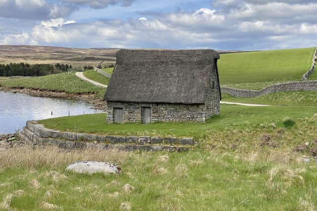
The wheelchair-friendly paths provide great views both from shore level and vantage points higher up. There are flocks of resident Canada and graylag geese. A small farming community lost their homes when Grimwith was expanded, but a 16th century cruck barn thatched with heather and moss remains on the eastern side.
Runswick Bay
Distance/time: 6 miles/3 hours
Map: OS Explorer OL27 North York Moors Eastern Area.
Start: Runswick Bay, signposted off A174 Whitby-Saltburn road at Ellerby and Hinderwell. Postcode for car park TS13 5HT.
Refreshments: Runswick Bay.
One of the best walks at the Yorkshire seaside, even in winter, the route begins in the huddled chocolate-box village of Runswick Bay (rebuilt after the original slipped into the sea in 1682) and follows part of the Cleveland Way National Trail and King Charles III English Coast Path to the dramatic headland of Kettleness.
An optional detour here allows a closer view of the 18th century alum quarries (alum was used in the leather tanning process) and famous Whitby jet mines.
The return leg joins a bridleway running along the trackbed of the old Whitby Redcar and Middlesbrough Union Railway, one of England’s most scenic lines when operational from 1883 until the closure in 1958.
It emerges on Ellerby Lane, where a right turn takes you back to the starting point. Check tide times when planning the walk since the beach may be inaccessible at high water. Visit www.britishbeaches.info
Hole of Horcum
Distance/time: 7 miles/3 hours
Map: OS Survey Explorer OL27, North York Moors Eastern Area.
Start: National Park car park at Saltergate on the A169 Pickering-Whitby road. Postcode YO18 7NR.
Refreshments: Hole of Horcum; Levisham.
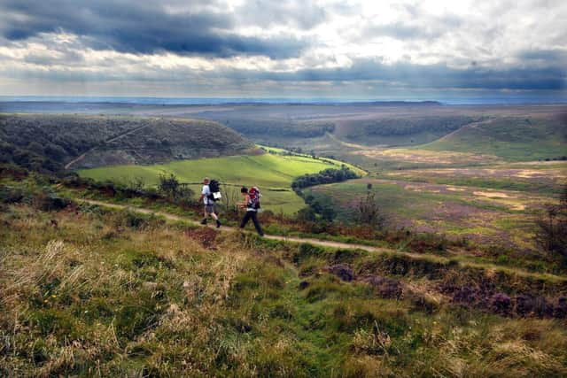
High on the list of Yorkshire classics, this route features perhaps the best-known view in the North York Moors National Park.
The dramatic geological cauldron of the Hole of Horcum is a 400ft deep amphitheatre created by springs scouring away light soils between harder flanks.
The Hole has long been associated with local myths, the best known involving a Norse giant, Wade, who is said to have scooped up a handful of soil to hurl at his wife.
The first part of the walk follows a bridleway west and south over Levisham Moor to Dundale Pond and a good track, Limpsey Gate Lane, leading into the picturesque village of Levisham.
To return, take a footpath into the wooded dale drained by Levisham Beck and follow the clear path below Horcum Slack to old farm buildings at Low Horcum.
Finally, a steep climb out of the hole leads back to the A169 and car park.
Towton Battlefield Trail
Distance/time: 2 1/2 miles/2 hours
Maps: OS Landranger 105 York or route split between OS Explorer 290 York, Selby & Tadcaster and OS Explorer 289 Leeds.
Start: Lay-by at memorial cross on B1217 southwest of Towton village. Towton (postcode LS24 9PB) is on A162 between Tadcaster and Sherburn-in-Elmet.
Much of this farmland walk to the south of Tadcaster is on permissive footpaths (not public rights of way) specially created to provide access to locations which saw significant action in the Battle of Towton, fought during a snowstorm on Palm Sunday, 29th March 1461.
It was one of the Wars of the Roses between troops loyal to Edward, Duke of York (later King Edward IV), and an opposing army supporting the Lancastrian King Henry VI.
As many as 38,000 men were said to have died in just ten hours, making it the bloodiest battle fought on English soil. Excellent information boards outline the trail created by the Towton Battlefield Society.
The Yorkists approached from the south but they were initially outnumbered.
But when reinforcements arrived the Yorkist ranks drove the Lancastrians from their defences above Cock Beck to win the day and secure the throne for Edward IV.
Temple Newsam Estate
Distance/time: 5 miles/2 hours.
Map: OS Explorer 289 Leeds.
Start: The estate is five miles from Leeds centre, signposted off A6120 Leeds Outer Ring Road and junction 46 of the M1. Postcode for Lakes car park LS15 0AE.
Refreshments: Temple Newsam House.
One of Yorkshire’s most historic mansions is surrounded by woods, park and farmland on the southeast edge of Leeds.
Starting from the Capability Brown-landscaped grounds, several circular walk options explore the estate’s 1500 acres on the eastern and southern boundaries of the estate.
Perhaps the best route follows a path down from the main car park to the other side of the ponds and joins a path signposted to Whitkirk, emerges on residential Darnley Lane, and passes Colton Methodist Church.
From there public footpaths visit Bullerthorpe Lane and Avenue Wood.
The return leg is via Dawson’s Wood, Dog Kennel Hill, and finally the magnificent Tudor-Jacobean Temple Newsam (admission charge), birthplace of Henry, Lord Darnley, second husband of Mary Queen of Scots, and a scene of much intrigue in Elizabethan times.
Its 40 rooms contain one of the UK’s finest collections of decorative arts and antiques including Chippendale furniture.
The Buck Stones
Distance/time: 6 miles/2 1/2 hours
Map: OS Explorer 297 Lower Wharfedale & Upper Washburn Valley.
Start: Ilkley Town Centre. Free parking at Darwin Gardens, Wells Road. Postcode: LS29 9TF.
Refreshments: White Wells; Ilkley.
Most walkers on Ilkley Moor don’t visit the arguably more interesting western side, where these gritstone outcrops are less visited than the iconic Cow and Calf.
Known as the Buck Stones, they provide an excellent viewpoint over a wide swathe of the moor and Wharfedale.
Begin walking from Wells Road in Ilkley centre or higher up at Darwin Gardens and follow the road until you run out of tarmac and join a track named Keighley Road.
Before the top of the moor at Keighley Gate, turn right to a monument known as Cowper’s Cross, once a boundary stone but ‘Christianised’ centuries ago, and continue along this path to the two sets of Buck Stones.
From the second, follow a wall down to the edge of the moor, where a right turn on the Bradford Millennium Way leads past the moor’s famous prehistoric relic, the Swastika Stone. Beyond it the path leads back to Wells Road.
Haworth & Stanbury
Distance/time: 4 1/2 miles/2 hours
Map: OS Explorer OL21 South Pennines.
Start: Haworth. Several village car parks. Postcode for starting point BD22 8DR.
Refreshments: Haworth; Stanbury.
Haworth is a popular winter walking centre even when snow is on the ground, there being few tricky gradients to negotiate in the surrounding moors and pastures.
This circular route, taking in the hill village of Stanbury, makes a good choice when hours of daylight are limited, and there is the added attraction of warming après-walk refreshments in Haworth.
The bleak Pennine landscape has hardly changed since the days of the Brontës, but an exception is Lower Laithe Reservoir, dating from 1925. Start from the hilltop square, pass the church, and turn left to pick up a sign for the Brontë Falls.
Follow the path almost to the Falls, but take a signposted footpath on the right, descend to a footbridge, ascend a field and aim for a house.
Turn right onto Back Lane and continue into Stanbury. From there, follow the road downhill, cross the dam and take the path on the left back into Haworth.
The Holme Valley
Distance/time: 10 miles/4 hours.
Map: OS Explorer 288 Bradford & Huddersfield.
Start: Holmfirth, 7 miles south of Huddersfield. Parking at Crown Bottom in Market Street. Postcode HD9 3AS.
Refreshments: Holmfirth; Upperthong; Holme.
At this time of year, perhaps the area should be called Winter Wine Country.
The TV cameras and much-loved characters like Compo, Foggy, and Cleggy may no longer wander these roads and tracks, but on a fine day the unchanged landscape of wooded cloughs and blue-surfaced reservoirs has a stark beauty when temperatures drop.
This walk makes use of the many green lanes which cut across the steep hillsides and airy Pennine tops and provide an excellent circuit of the Holme Valley.
A steep climb from Holmfirth’s Main Street leads to the appropriately named hamlet of Hill, and from there the route runs west along part of the Holme Valley Circular (HVC) walk to Digley Reservoir.
From the classic Pennine village of Holme, the return leg begins by crossing the dam between Brownhill and Ramsden Reservoirs. Leave the HVC at Upper White Gate to follow Cartworth Moor Road back into Holmfirth.
Yorkshire Sculpture Park
Distance/time: 4 miles/2 hours
Map: OS Explorer 278 Sheffield & Barnsley.
Start: Weston car park, Yorkshire Sculpture Park on A637 Huddersfield Road, a mile from junction 38, M1. Postcode for satnav WF4 4JX.
Refreshments: Kitchen Cafe and Weston Restaurant.
Not just a park peppered with amazing sculptures, this valley in the upper reaches of the River Dearne has itself been beautifully sculpted to create a superb walking landscape.
The park opened in 1977 as an open-air ‘gallery without walls’ in 500 acres surrounding Bretton Hall, an 18th-century country mansion.
Exhibits abound by sculptors including Henry Moore, Barbara Hepworth, and Antony Gormley.
Many of the paths run through mature woodland and you may well deviate from the route to see some of the 90 different works.
The parkland contains two long lakes, and in late winter there is a substantial heronry next to the Cascade Bridge.
From the visitor centre (an admission ticket is required for the park), the route crosses a dam at the eastern end of Lower Lake and runs through Menagerie Wood and Bath Wood before returning by Bridge Royd Wood, Bretton Hall and Bretton Country Park.
North Ferriby & Welton
Distance/time: 7 miles/3 hours.
Map: OS Explorer 293 Kingston upon Hull & Beverley.
Start: Riverside car park at junction of Humber Road and Redcliff Drive, North Ferriby. Nearest postcode HU14 3DN.
The Humber is the largest tidal estuary in the North and drains one-fifth of England’s land surface.
It presents an ever-changing scene for walkers along the two-mile stretch of waterfront included in this route.
Turning point is the pretty Hull satellite village of Welton, where legendary highwayman Dick Turpin was arrested in 1739 while drinking at the Green Dragon pub. He was subsequently hanged at York for horse theft.
The walk includes sections of the Trans Pennine Trail, a 215-mile path from Hornsea to Southport, and the Yorkshire Wolds Way, a 79-mile trek across the crescent of chalk hills to Filey Brigg.
Outbound, the Humber is accompanied to Welton Clough, then Common Lane is followed north to cross the A63 to Welton.
In the village, pick up the Wolds Way at a green above picturesque St. Helen’s Church and return via the woodland of Bow Plantation, Terrace Plantation, and Long Plantation.
Stanage Edge
Distance/time: 7 1/2 miles/3 hours
Map: OS Explorer OL1 Peak District Dark Peak Area.
Start: Upper Burbage Bridge Car Park, 9 miles southwest of Sheffield on unclassified Ringinglow Road signposted to Hathersage. Approx. postcode S32 1BR.
Refreshments: Ringinglow; Hathersage.
Traversing part of spectacular Stanage Edge, a 12-mile line of gritstone outcrops, is one of the North’s finest outings.
Straddling the South Yorkshire and Derbyshire border, the route follows part of the 53-mile Sheffield Country Walk, which uses an old packhorse road and provides some of the finest viewpoints along the Edge.
Stanage is derived from ‘stone edge’, and parts of the ridge were once quarried to produce grindstones for flour mills and Sheffield’s early cutlery makers.
To begin the walk, cross the road from the car park and turn left to use the roadside path.
On a bend, follow the path bearing right towards the ridge ahead. The Cowper Stone, a large block of gritstone, is passed before a trig point at the start of Stanage Edge.
If you have time, the ridge walk can terminate at the A57 Sheffield-Manchester road, but many will retrace steps from the trig point at High Neb.