North Yorkshire weather: Strong winds expected as Met Office issues weather warning
As the county stil recovers from Storms Dudley, Eunice and Franklin, Storm Gladys is set to hit the north of England today and tomorrow.
The Met Office has issued a yellow weather warning for snow and wind in Scotland, while a yellow weather warning for wind has been issued covering parts of the North.
Advertisement
Hide AdAdvertisement
Hide AdThe west of North Yorkshire is covered by the weather warning, although the rest of the county is still expecting to experience more high winds, snow and rain.

Heavy rain is set to hit the area later this evening.
The Met Office forecast says: "A bright but windy start for most, with gales in places. Some patchy light rain at times, mainly over the Pennines, but brighter spells to the east. Heavier rain, and later hill snow, moving southeast through the evening. Maximum temperature 11 °C.
"Tonight, a band of rain and hill snow clearing away south, followed by colder conditions with clear spells and winds easing. Patchy frost with some wintry showers developing later. Minimum temperature 0 °C."
A yellow weather warning means:
- Delays for high-sided vehicles on exposed routes and bridges likely
Advertisement
Hide AdAdvertisement
Hide Ad- Some delays to road, rail, air and ferry transport are likely
- Probably some bus and train services affected, with some journeys taking longer
- Some short term loss of power and other services is possible

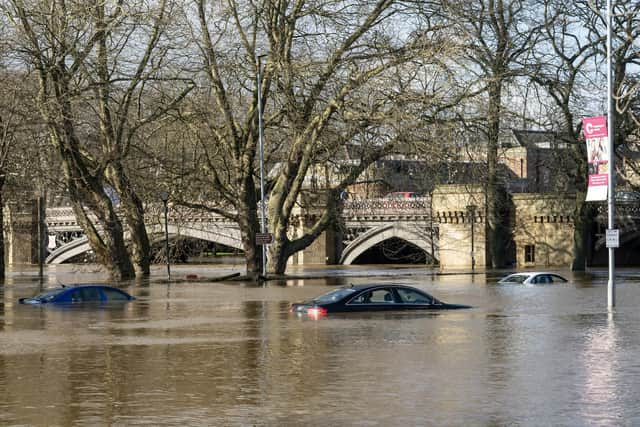
There are also still 19 flood warnings in place across Yorkshire, and 14 flood alerts.
Advertisement
Hide AdAdvertisement
Hide AdThe Environment Agency (EA) is urging communities in parts of the West Midlands and Yorkshire, especially those along the Rivers Severn and Ouse, to be prepared for significant flooding following high rainfall from Storm Franklin.
Around 400 properties have flooded across different parts of the country as a result of the heavy rain.
Flood warnings
River Aire at Allerton Ings, Barnsdale Road and Properties
River Aire at Birkin
River Aire at Chapel Haddlesey
River Aire at East Haddlesey
River Aire at Hillam, Monk Fryston and Gateforth
River Aire at Hirst Marsh and West Marsh
River Aire at Mickletown
River Aire at West Haddlesey
River Derwent at Buttercrambe Mill
River Don at Fishlake
River Ouse at Acaster Malbis
River Ouse at Acaster Selby
River Ouse at Bishopthorpe
River Ouse at Naburn Lock
River Ouse at York - Fulford and Fordlands Road
River Ouse at York - riverside properties
River Ouse at York - Skeldergate and Tower Street
River Ouse at York - St George's Field and Queen's Staith
River Ure at Aldwark Bridge to Cuddy Shaw
Flood alerts
Burstwick and Keyingham Drains
Lower River Aire catchment
Lower River Derwent
Lower River Don catchment
Lower River Nidd catchment
Lower River Ure
Middle River Aire catchment
River Foulness and Market Weighton catchment
Tidal River Aire catchment
Tidal River Ouse from Naburn Lock to Selby
Tidal River Ouse from Selby to Faxfleet
Tidal River Wharfe
Tidal Trent for riverside areas from Gainsborough to the Humber confluence
Upper River Ouse