
Flood experts turn to 'whole-system modelling' to explore resilience options in Yorkshire

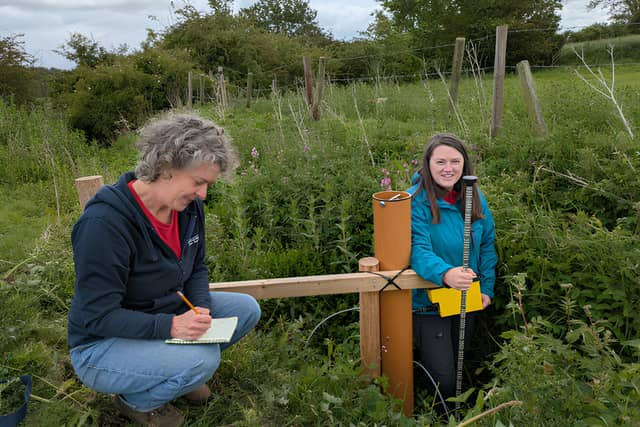

Flood resilience programme Ousewem is using whole-system modelling to explore how nature-based solutions could help reduce peak river flows and improve water quality across York and North Yorkshire, as Graham Walker finds out.
Flooding in York does not begin at the city’s boundaries.
The water flowing through the city has travelled through a vast network of rivers, tributaries and landscapes across North Yorkshire.
What happens many miles upstream could therefore influence what eventually happens downstream.
That is the thinking behind whole-system modelling – looking at how different measures could work together across an entire river catchment, rather than examining individual projects in isolation.
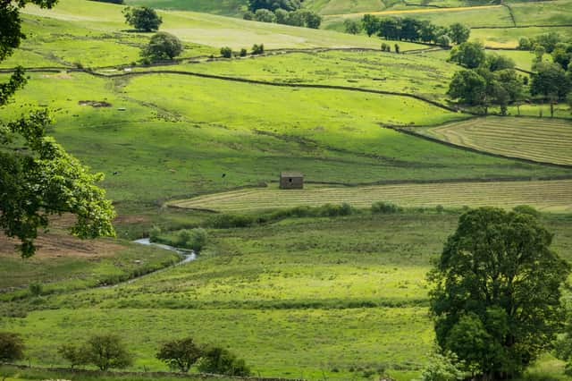
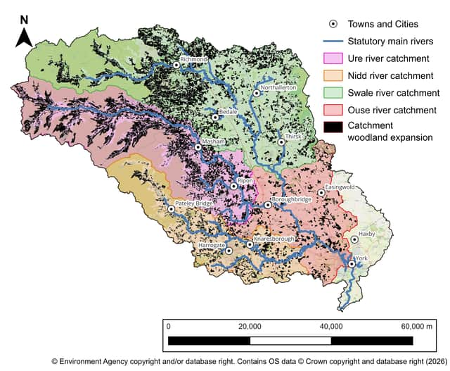
Now whole-system modelling undertaken through Ousewem, a £5.9m York and North Yorkshire flood resilience programme, is helping to build a bigger picture of how nature-based solutions across the Swale, Ure, Nidd and Upper Ouse (SUNO) catchment could contribute to reducing peak river flows and improving water quality.
The SUNO catchment is vast and complex.
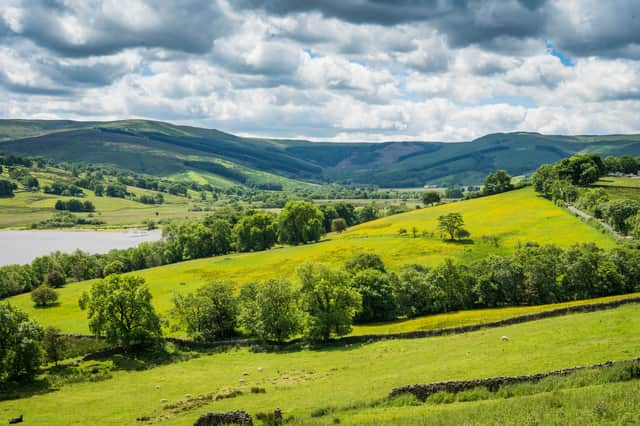
Water eventually reaching York has passed through landscapes with different geology and through a network of rivers and tributaries.
Potential changes downstream therefore depend not simply upon what happens at one farm or in one part of a river system, but upon the cumulative effects of interventions across many locations.
And the modelling is helping researchers explore one particularly important question: what scale of action could be needed to make a measurable difference across an entire catchment?
Dr Eleanor Pearson, a flood risk specialist at Skipton-based JBA Consulting, who is closely involved in Ousewem’s whole-system modelling work, said: “The whole-system modelling suggests we will need a significant amount of land use change to allow us to potentially see a change in flood risk in York.
“It may however be possible to achieve flood risk benefits with less land use change in different parts of the catchment.”
For Mark Henderson, Flood Risk Manager at City of York Council, that emerging evidence also raises important questions about where future action and investment could be focused.
He said: “York cannot address future flood risk through any single approach alone.
“Larger-scale, catchment-wide landscape interventions, such as tree planting and natural flood management measures, involving a whole-system approach, will enable decision-makers to identify locations where there is the biggest flood reduction benefit, focusing investment decisions in priority locations.”
One modelled scenario provides a striking illustration of the scale involved.
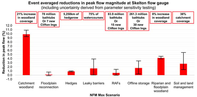
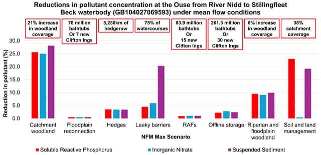
The modelling indicatively suggests that increasing woodland cover by more than 20 per cent beyond current levels could result in approximately a 10 per cent reduction in peak flow at York, while potentially also contributing to reductions in diffuse agricultural pollutants.
But Dr Pearson stresses that the figure needs careful interpretation.
She said: “The modelling results suggest an aspiration for land use change and indicates what effect this may have on flood risk, however without more detailed modelling, we cannot ascertain what a 10% reduction in peak flow means for water levels in York.”
It is therefore an ambitious modelled scenario rather than a prescription for what should happen across North Yorkshire.
But it helps illustrate the potential scale of coordination, partnership and investment involved in moving from individual nature-based projects towards seeking outcomes across an entire catchment.
Ousewem is led by City of York Council in close collaboration with North Yorkshire Council and funded by Defra as part of a £200m Flood and Coastal Innovation Programme.
Its delivery partners include JBA, Natural England, Yorkshire Dales Rivers Trust and the University of York.
Over the past five years it has worked with land managers, communities and partners to explore measures including woodland creation, changes to soil and land management, floodplain reconnection and features designed to slow and store water.
Whole-system modelling allows that learning to be explored at a much larger scale.
While individual projects can help build evidence about how different approaches perform in particular landscapes, modelling across the SUNO catchment allows researchers to explore what could happen when different measures operate collectively.
Flood resilience is only part of that picture.Nature-based interventions designed to slow and store water can potentially provide wider benefits including improved water quality, reductions in sediment and nutrient loading, biodiversity and habitat improvements, carbon storage and more resilient approaches to land management.
The modelling explores potential changes in phosphorus, nitrate and suspended sediment concentrations alongside reductions in peak river flows.
Mr Henderson said: “The evidence from Ousewem is hugely valuable and encompasses both flood risk and water quality benefits on a catchment scale.
“The evidence can and will be used by multiple partners to enable closer partnership working and the delivery of ‘stacked’ benefits in locations across North Yorkshire.”
But modelling is not the same as predicting precisely what will happen.
As Dr Pearson explained: “The model is a simplified representation of a highly complex system. It is limited by assumptions, data quality, and available evidence.
“The model can suggest what may happen, however on the ground results may differ due to local conditions, unforeseen events, management practices, and natural variability.”
Its role is therefore not to dictate what should happen in every field, farm or community, but to help build understanding of the relationships between interventions, their potential cumulative effects and the scale at which action may be required.
As Ousewem approaches the final year of its current funding, attention is increasingly turning to how that evidence could help inform longer-term approaches to planning, partnership and investment.
Mr Henderson said: “There is a need for landowners/policy makers/investors to come together in cross cutting ways to use the evidence base from Ousewem to deliver landscape change on a much bigger scale to combat the ever-increasing risks from climate change.
“A co-ordinated approach is essential to create resilience from increasing flood risk, drought and improve biodiversity which in turn will ultimately sustain our economic well-being.”
There is no single intervention – or simple answer – for a river system stretching across such a large part of North Yorkshire.
But by looking beyond individual projects and considering how an entire catchment functions as a connected system, whole-system modelling is helping to build the evidence needed to inform future choices.
Local evidence can help build understanding of what happens on the ground.Whole-system modelling is helping to explore what it could take to make a difference at scale.
BLOGS:
READ MORE: